8/6/2023 - 8/12/2023
Climate in the News:
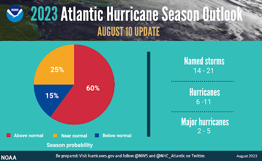
As the peak of the Atlantic Hurricane season is on the horizon, NOAA has issued an update to their Atlantic Hurricane season forecast. Their prediction has shifted from a previously forecasted near-normal tropical activity to above-normal activity. They believe that current atmospheric and oceanic conditions, such as the record-warm sea surface temperatures outlined in the 7/16/2023 - 7/22/2023 weekly summary, will counteract the effects of El Niño on tropical storm development. According to the Climate Prediction Center, there is currently a 95% chance that El Niño will continue through the Northern Hemisphere winter. Typically, this leads to more wind shear in the atmosphere, which rips tropical storms apart. However, in their forecast, NOAA outlines that they anticipate a below-normal wind shear forecast despite the El Niño pattern.
Weather Synopsis:
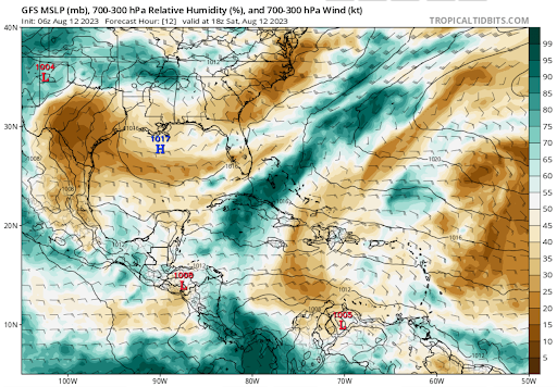
In terms of tropical weather, only sea surface temperatures and wind shear have been discussed, but there are other factors that contribute to the strengthening and dissipation of a tropical system. A variable that can hinder tropical storm development and strengthening is the presence of Saharan air layers over the Atlantic Ocean. This Saharan air contains a lot of dust, which can cause a lot of downdrafts (descending air currents) to form around a storm. In a hurricane, air is constantly being circulated upward, so this opposition of force weakens the storm.
Temperature:
Overall, summer days in August are hot across most of the region. It is hot both during the day and at night for most areas, with high humidity levels near the coast due to the prevailing southerly winds that bring moisture from the Gulf of Mexico.
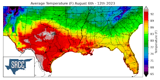
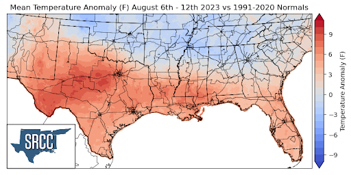
As the record-breaking heat continues into the month of August, it brings along excessive heat warnings, advisories, and the risk of wildfires. A high-pressure center was situated over South Texas and Louisiana for much of the week, bringing further above-average temperatures to the majority of the climatic region. Daily average temperatures reached as high as 95 degrees Fahrenheit in areas of North Texas. Texas and Louisiana observed the warmest temperatures last week, with much of the two states experiencing daily average temperatures in the 90s. Nearly the entire southern portion of the climatic region encountered above-average temperatures last week, where anomalies ranged from 9 degrees higher than normal in North Central Texas to 3 degrees above normal in central Mississippi.
While half of the region was experiencing above-average temperatures, Oklahoma, Arkansas, Tennessee, and northern Mississippi enjoyed temperature anomalies about 3 degrees below normal, resulting in daily average temperatures ranging between 72 and 86 degrees Fahrenheit for these states.
Precipitation:
With the majority of the region being in a humid subtropical climate, rainfall is common at any point of the year. Frequently, during the summer months, sea breezes initiate thunderstorms and rain showers, which are quite common along the coastal areas.
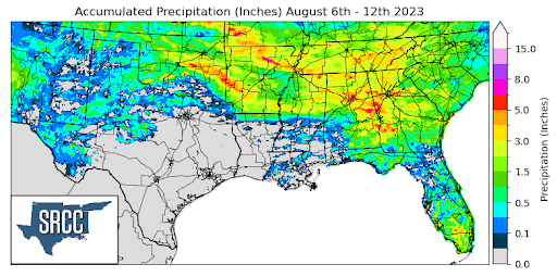
Precipitation was relatively widespread across the northern portions of the climatic region, including the states of Oklahoma, Arkansas, Tennessee, and northern Mississippi. Due to these frequent showers throughout the week, accumulated precipitation totals for the week averaged about 1.5 inches across the four states, reaching as high as 8.0 inches in Northern Arkansas. Taking a broader perspective, precipitation in the region last week was heavily concentrated in the northern half of the region, leaving much of the southern states to not see so much as a trace.
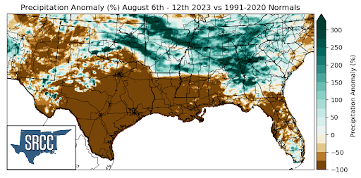
The states that witnessed above-average precipitation compared to normal were Oklahoma, Arkansas, and Tennessee. Both the entire states of Arkansas and Tennessee experienced precipitation anomalies that were 200% greater than normal last week.
Many areas of Texas, Louisiana, and Mississippi remained dry last week. Consequently, the majority of Texas, Louisiana, and southern Mississippi experienced precipitation anomalies of around -100%.
Records/Extremes:
- 8/6/2023: Stratford, TX: 78 mph wind gust associated with a severe thunderstorm
- 8/7/2023: Woodlum, AR: 2.5 inch hail
- 8/7/2023: Karns, TN: EF 2 Tornado
- 8/8/2023: College Station, TX: New record for consecutive days over 100°F at 31 days
- 8/8/2023: Baton Rouge, LA: New record for consecutive days over 100°F at 10 days