7/16/2023 - 7/22/2023
Climate in the News:
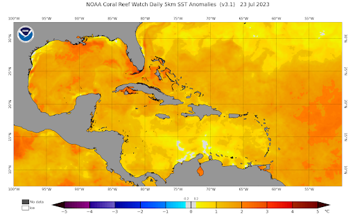
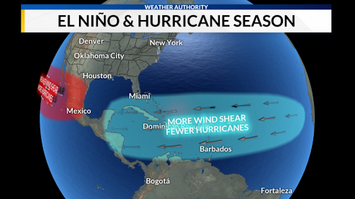
The media has been talking a lot about abnormally warm sea surface temperatures off the coast of Florida. But sea surface temperatures are just as anomalously warm in the Gulf of Mexico, off the coast of Louisiana. These warm gulf waters are a major fuel source for any tropical storm that makes its way into the Gulf of Mexico. All other factors that can contribute to a hurricane's growth or dissipation aside, the warmer the water, the stronger the storm. That is why the media is giving these sea surface temperatures so much attention. But sea surface temperatures are not the only thing that impacts tropical storms. One significant factor this hurricane season is the presence of vertical wind shear. Wind shear will rip apart a tropical storm and also hinder thunderstorms from organizing into a tropical system. Officially in an El Nino advisory by the CPC, El Nino typically brings with it higher levels of vertical wind shear, which is bad for tropical storms. The interaction of these two phenomena has made the intensity of this tropical weather season relatively hard to predict.
Weather Synopsis:
This hurricane season, the formation of a tropical system depends heavily on the upper-level winds. While El Nino strengthens the wind shear in the tropics, daily weather patterns can lead to conditions that would allow for wind shear values to be low enough for hurricane development. It is these daily changes in the upper atmospheric weather patterns that will allow for the formation and later development of these hurricanes as they access the warm waters of the Gulf of Mexico. So, when looking at the intensity of this Atlantic hurricane season, it is important to look not just at anomalously warm sea surface temperatures but also at other factors that affect hurricane development and sustainability. Coming in early August the Climate Prediction Center will update their Atlatic seasonal outlook, just prior to the peak in hurricane season.
Temperature:
Overall, summer days in July are hot across most of the region. It is hot both during the day and at night for most areas, with high humidity levels near the coast due to the prevailing southerly winds that bring moisture from the Gulf of Mexico.
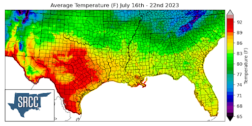
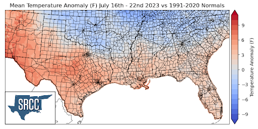
As the summer of record-breaking heat continues, extreme heat warnings and advisories are almost everyday in some portions of the southern climate region. As an upper-level ridge still remains to the west, it brings with it some above-average warmth to the state of Texas. Daily average temperatures for the majority of the state were 92 degrees Fahrenheit, with many areas not seeing temperatures below 80 degrees even at night. Texas, Louisiana, and Mississippi all were anomalously warm last week, with Louisiana and Mississippi being 2 to 5 degrees above normal. But, portions of far west and central Texas saw temperature anomalies of up to 7 degrees greater than normal. Overall, the region's daily average temperature was between 80 and 85 degrees for the majority of the region. Arkansas experienced temperatures around normal last week, while Oklahoma and Tennessee both saw negative temperature anomalies of about 3 degrees Fahrenheit.
Precipitation:
With the majority of the region being in a humid subtropical climate, rainfall is common at any point of the year. Frequently, during the summer months, sea breezes initiate thunderstorms and rain showers, which are quite common along the coastal areas.
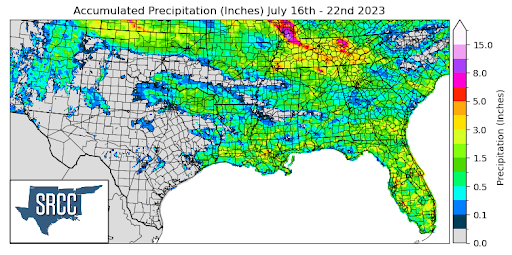
Pop-up showers and severe thunderstorms were common last week all across the state of Tennessee. Due to these frequent storms throughout the week, accumulated precipitation totals for the week averaged about 4.0 inches across the state, reaching as much as 8.0 inches in some areas. Taking a broader scale, precipitation across the region last week was heavily concentrated in one state, leading to an average accumulated precipitation amount of 0.25 inches across the entire region.
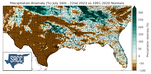
Regions that saw above-average precipitation when compared to normal were Tennessee, Northern Oklahoma, and Northeast Texas. In these regions, precipitation anomalies were 250% greater than normal.
Many areas of Texas remained dry last week, and some other areas joined it with these negative precipitation anomalies. As a result, the majority of Texas, Central Oklahoma, southern Arkansas, and central Mississippi saw precipitation anomalies around -100%.
Records/Extremes:
- 7/16/2023: Dalhart, TX: 70 mph winds
- 7/17/2023: Bartlesville, OK: 1.75 inch hail
- 7/17/2023: El Paso, TX: Record daily high temperature of 109°F
- 7/21/2023: Collierville, TN: 76 mph winds
- 7/21/2023: Meigs County, TN: 5.36 inches of rain via CoCoRaHS