August 2023
Significant Weather Events:
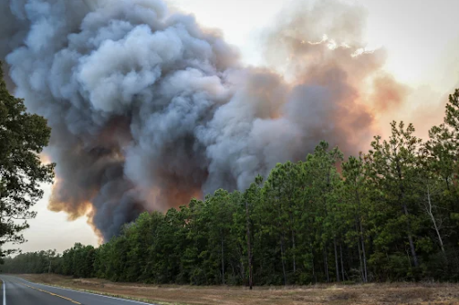
Many extreme weather events occurred this August, from an EF2 tornado in Tennessee (only the second on record in eastern Tennessee) to numerous wildfires in Texas and Louisiana. For areas of Texas and Louisiana, there has been an extreme lack of rainfall this past month, only further fueling wildfires and drought in the two states. Prolonged heatwaves have also overtaken the majority of the region for the entire month. With the combination of this extreme heat and the lack of precipitation, wildfires were able to easily ignite and grow. During August, the Texas A&M Forestry Service typically responds to 151 wildfires, but this year they responded to 518 wildfires in August. Louisiana has now had more than 511 wildfires burned in the month of August, according to the state's agriculture and forestry commissioner. Wildfire activity is typical for the state. The state average from 1985 is 67,000 acres burned a year. So far, an estimated 60,000 acres have burned so far this year.
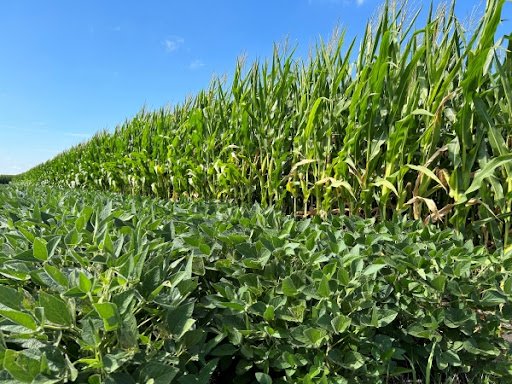
Thankfully, due to Tropical Storm Harold, some areas of South Texas were able to get some much-needed rain, which improved drought conditions in areas where the storm tracked. To read more about Tropical Storm Harold, visit the 8/20/2023 - 8/26/2023 weekly summary. While several states stayed very dry this August, Tennessee saw substantial amounts of rain and thunderstorms as many storm systems hit the state, causing high winds, hail, and even an EF2 tornado in Karns, TN on August 7th Thankfully, no injuries or deaths were reported. These frequent thunderstorms have led to the majority of Tennessee seeing above-average or near-normal rainfall amounts, and combined with near-normal temperatures for the month of August, crops are thriving. In Tennessee, corn is rated 74% good to excellent, soybeans 79% good to excellent, and cotton 72% good to excellent, according to Brownfield Ag News. Unfortunately, Texas has not been as lucky and has not received as much rain, and temperatures have been record-breaking. Due to drought conditions, Central Texas farmers battled cracking soil and were unable to plow due to low soil moisture. AgriLife Today says in Central Texas, “The cotton crop deteriorated near the point that additional rainfall will not help yields.”
Temperature:
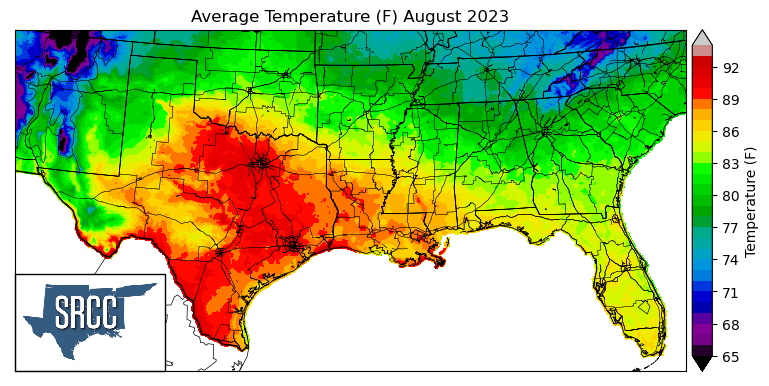
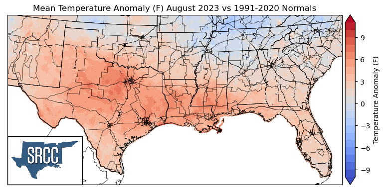
Overall, temperatures were above normal for much of the Southern Region in August, except in Tennessee where temperatures were at or just below normal. The largest departures from normal were observed in far North-Central Texas, averaging 5-7 degrees Fahrenheit above normal, and in Tennessee, where temperatures averaged 0-1.5 degrees below normal for the month of August. The majority of the climate region experienced many days of excessive heat warnings and heat advisories, and in Texas and Louisiana, this was an almost daily occurrence. The excessive heat this August can be best exemplified by looking at consecutive days over 105 degrees in College Station, TX. This new record-long streak of 15 days lasted from July 31st to August 14th, with daily high temperatures reaching as high as 112 degrees Fahrenheit, tying the all-time hottest recorded temperature. Another way this summer's and last month's excessive heat can be understood is by looking at Pascagoula, MS. August 2023 is now the all-time warmest month on record, breaking the previous record (from July 1981) by 0.6 degrees. The daily average temperatures for the month exceeded 90 degrees Fahrenheit in Central and South Texas, with the majority of the southern region experiencing daily average temperatures between 88 and 78 degrees. Some of the coldest daily average temperatures were found in the Great Smoky Mountains of Eastern Tennessee, where average temperatures were as low as 70 degrees Fahrenheit.
Precipitation:
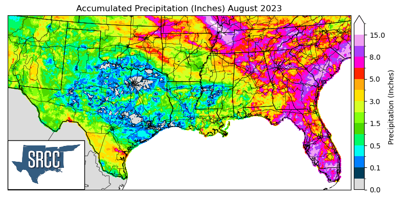
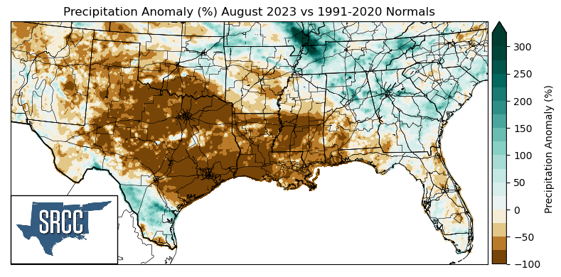
Most areas of the Southern Region during August received less precipitation than normal or near-normal precipitation amounts. The largest negative departures from normal were seen in North Texas, Central Texas, East Texas, Southeast Texas, Louisiana, Southern Mississippi, and Southern Oklahoma, where precipitation was zero. Some of the greatest positive anomalies were observed in Northwestern Tennessee, where precipitation was about three times normal. Rainfall was relatively widespread in Oklahoma, Arkansas, and Tennessee, with accumulated precipitation averaging about 4.0 inches for the month of August across the three states. However, Tennessee saw some substantial amounts of precipitation; in Crossville as of August 29th, 9.04 inches of rain accumulated this month. This is the 2nd wettest August on record for Crossville. Unfortunately, though, the areas that stayed particularly dry in the month of August were areas already not receiving any rain in July. Via CoCoRaHS, portions of Williamson County, TX, have not received any rainfall in 65 days, but on August 28th, areas in Georgetown finally managed a few hundredths of an inch.
Drought:
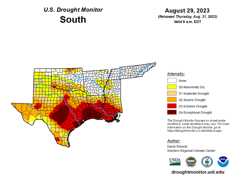
While drought intensity has improved for the Northern border of the climate region and areas of South Texas, exceptionally dry conditions in Texas, Southern Oklahoma, Louisiana, and Southern Mississippi have led to a worsening of drought conditions among those regions. At the beginning of the month, 58% of the region was experiencing varying levels of drought severity. However, as of August 29th, that number has increased to 74%. Not only is the land area of drought increasing, but so has the severity of drought, with 25% of the region currently experiencing D3-D4 drought conditions compared to only 3% at the beginning of the month.
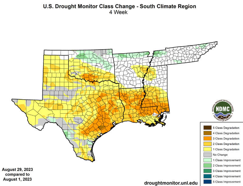
The northern border of the climate region has seen a significant improvement in drought conditions, thanks to many evening pop-up showers and thunderstorms this August. This has resulted in one and two-class improvements in drought conditions in some areas. Evidence of Tropical Storm Harold is also present among the one and two-class improvements in South Texas. Conversely, dry conditions in Texas, Louisiana, Southern Mississippi, and Southern Oklahoma have led to broad three-class degradations in those areas. Exceptional heat and prolonged dryness have led to some isolated four-class degradations, located in Wharton County, TX, and Southeast Mississippi. As hot and dry conditions are expected to continue into September, the Climate Prediction Center has identified areas of Texas, Oklahoma, Louisiana, Arkansas, and Mississippi as being at "rapid onset drought risk."