9/24/2023 - 9/30/2023
Climate in the News:
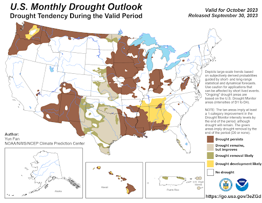
With Fall here, the Southern Climate region is expecting to see cooler temperatures and more precipitation than recent weeks. According to the Climate Prediction Center's Monthly Precipitation Outlook, almost all of Texas and Oklahoma are expected to see above-normal chances of precipitation during October. Looking at how that translates to drought conditions, drought removal is likely in the Texas Panhandle, West-Central Texas, and Central Oklahoma. While drought is expected to improve, it is expected to still remain throughout Texas and Southern Oklahoma. Forecasted near-normal precipitation chances along the Texas-Louisiana border, Louisiana, and Arkansas are leading to drought conditions expected to persist throughout the month of October in those areas. Finally, below-normal precipitation chances forecasted for Mississippi and Tennessee have led drought forecasters to expect drought to persist in Southern Mississippi, while drought development is expected in Northern Mississippi and Tennessee.
Weather Synopsis:
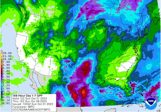
Corresponding with the Climate Prediction Center’s Monthly Precipitation Outlook, the Weather Prediction Center in their 7-Day Total Precipitation Forecast is expecting values of 1.50 inches and greater for Central Texas and Oklahoma. These chances for rain are driven largely by the upper-level weather patterns. This Tuesday an upper-level trough is expected to move across the Southern Plains and as it moves it will provide a substantial lifting mechanism for thunderstorms to fire out in front of it, leading to these forecasted high precipitation totals.
Temperature:
Overall, fall days in September are still fairly warm across most of the region. Although, weekly cold fronts are quite common bringing with them cooler, more fall-like temperatures.
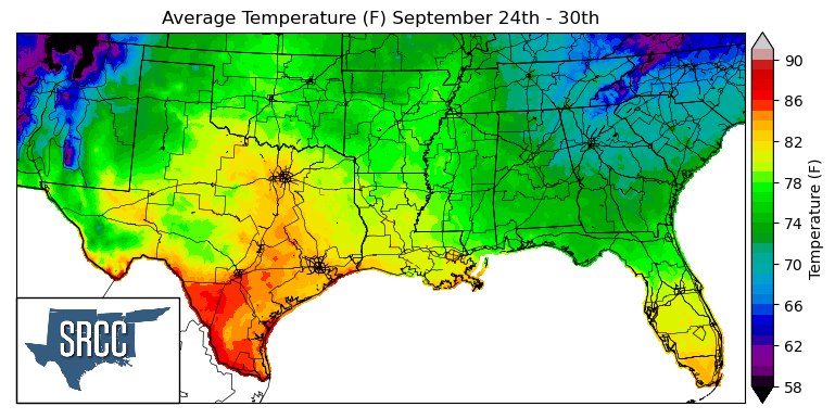
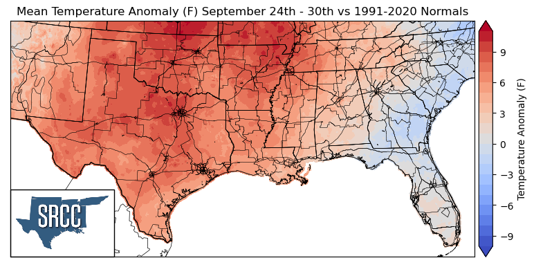
Some have called last week a “second taste of summer” as the entirety of the southern climate region experienced temperatures well above normal last week. A broad high-pressure center was situated over the climate region toward the middle to end of the week. This brought above-average temperatures to the entire region, leading to Daily average temperatures as much as 9 degrees Fahrenheit in North-Central Texas, Oklahoma, and Arkansas. Daily average temperatures reached as high as 90 degrees Fahrenheit in South Texas. Overall, daily average temperatures for the region ranged from 85 to 71 degrees Fahrenheit in the Southern Climate region.
Precipitation:
With the majority of the region being in a humid subtropical climate, rainfall is common at any point of the year. Frequently, during the fall months, cold fronts bring with them showers and thunderstorms. The boundary between the cold and warm air masses serves as a trigger mechanism for storms.
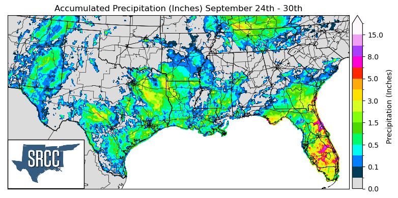
Last week's “cool” front stalled in South Texas turning into a stationary front dropping rain over areas of Texas and Louisiana as the front sat. Thanks to this frontal boundary and the storms it produced, widespread precipitation was observed in Eastern Texas and Western Louisiana, both areas struggling with drought.
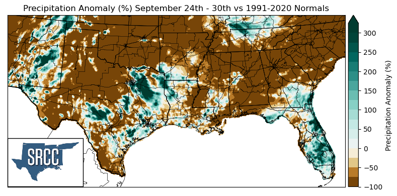
Unfortunately, not all of the climate region was lucky enough to receive widespread precipitation. North Texas, West Texas, Oklahoma, Northern Arkansas, Northern Mississippi, and Southern Tennessee saw little to no precipitation last week, leading to precipitation anomalies of -100%.
The areas that witnessed above-average precipitation compared to normal were primarily in Eastern Texas. Some of the largest precipitation anomalies experienced were in Northeast Texas where precipitation was about three times normal.
Records/Extremes:
- 9/24/23: Holdenville, OK: 75 mph wind gust associated with a severe thunderstorm
- 9/25/23: Round Rock, TX: 3.75 inch hail reported
- 9/27/23: Vicksburg, MS: Tied Daily Record High at 96°F
- 9/30/23: College Station, TX: Daily Record High at 100°F
- 9/30/23: Greenville, MS Tied Daily Record High at 96°F