9/17/2023 - 9/23/2023
Climate in the News:
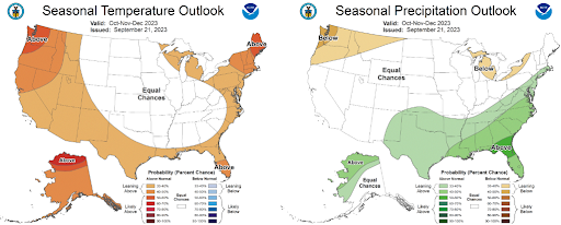
While meteorological fall started September 1st, the Autumnal Equinox this past Saturday marks the start of Fall. Taking a look at what to expect for the season, the Climate Prediction Center has outlined expected seasonal temperature and precipitation as compared to normal in their Three Month Outlook. Much of Texas, as well as Southern Louisiana, and coastal Mississippi, are expected to have up to a 40% chance of above-normal temperatures. Whereas, the rest of the climate region has equal chances for above or below-normal temperatures. Looking at expected precipitation, almost the entirety of the southern climate region is expected to experience above-normal precipitation. Specifically, Southern Louisiana and Southern Mississippi have up to a 50% chance of seeing above-normal precipitation amounts.
Weather Synopsis:
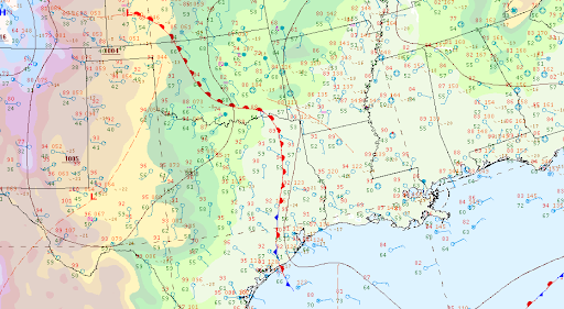
Depicted below by the surface analysis is a warm front lifting northwest into Western Oklahoma and Arkansas, from last Tuesday. This continued through the night eventually becoming a stationary front, firing many thunderstorms along the way. Air tends to move toward a stationary front from both sides, helping to maintain and intensify the temperature difference across the front. In the process it lifts the air, providing the necessary forcing for thunderstorms to occur.
Temperature:
Overall, fall days in September are still fairly warm across most of the region. Although, weekly cold fronts are quite common bringing with them cooler, more fall-like temperatures.
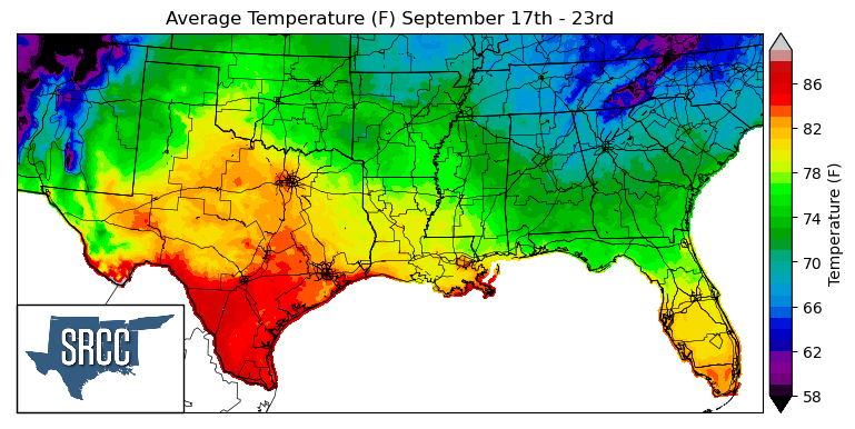
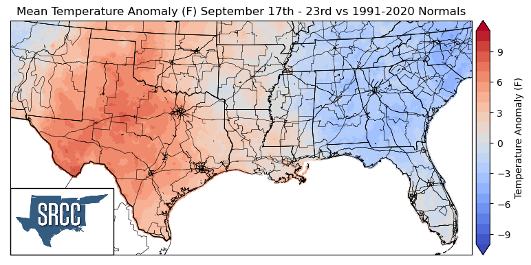
As September continues, hot humid days in Texas and Oklahoma left it feeling much like summer last week there. Upper-level ridging last week in Texas and Oklahoma led to temperatures above normal in the two states. Whereas, near-normal temperatures in Arkansas and Louisiana and even below-normal temperatures were experienced in Tennessee and Mississippi last week. This led to daily average temperatures ranging from 83 to 66 degrees Fahrenheit for the rest of the majority of the southern region, excluding south Texas where daily average temperatures sat around 90 degrees Fahrenheit.
Precipitation:
With the majority of the region being in a humid subtropical climate, rainfall is common at any point of the year. Frequently, during the fall months, cold fronts bring with them showers and thunderstorms. The boundary between the cold and warm air masses serves as a trigger mechanism for storms.
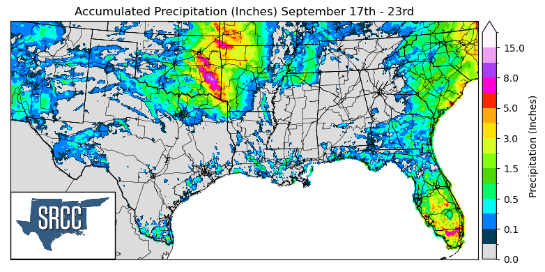
As discussed above, a front became stationary last week across Oklahoma and Western Arkansas. Thanks to this warm front and the storms it produced, widespread precipitation was observed in Eastern Oklahoma and Western Arkansas, where precipitation accumulations were three times greater than normal. As much as about 10.0 inches was accumulated last week in a localized area of Southeast Oklahoma.
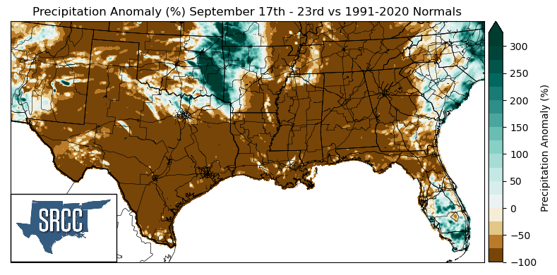
Overall though, the climate region did not see much rain. Precipitation was not widespread last week which led to many areas receiving no sizable precipitation. Due to this negative precipitation anomalies of 100% were experienced widespread throughout Texas, Western Oklahoma, Louisiana, Eastern Arkansas, Mississippi, and Tennessee.
Records/Extremes:
- 9/19/2023: Quanah, TX: 2.75 inch hail reported
- 9/20/2023: Tipton, OK: 74 mph winds associated with a severe thunderstorm
- 9/20/2023: Benton County, AR: 4.85 inches of rain via CoCoRaHS submission
- 9/21/2023: College Station, TX: Broke the record for most days over 100°F in a year at 70 days
- 9/22/2023: Fritch, TX: 87 mph wind gust associated with a severe thunderstorm