9/10/2023 - 9/16/2023
Climate in the News:
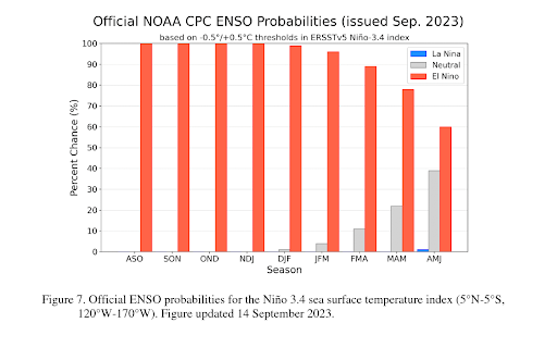
Outlined in the September 2023 ENSO Outlook, El Niño has a greater than 95% chance of continuing through at least January - March, as depicted in the bar graph below. There is also a 71% chance that a strong El Niño peaks this winter, meaning a stronger chance for El Niño impacts to occur on a broad scale. A strong El Niño can increase the likelihood of certain extremes. Conditions expected in the Southern United States during El Niño winters are wetter and cooler. The Farmers Almanac Winter Weather Forecast is predicting mild wet conditions for the majority of the climate region, which lines up with a typical El Niño.
Weather Synopsis:
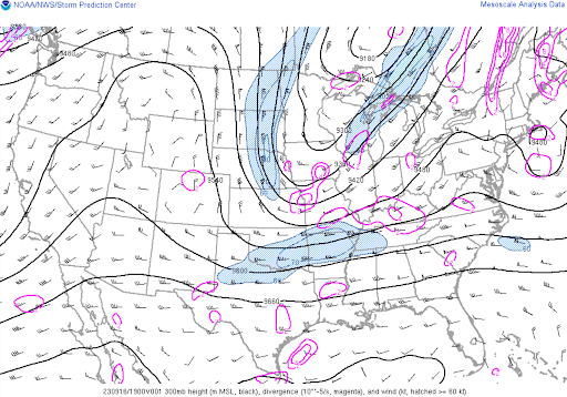
Depicted by the image of the jet stream below, an upper-level pattern change was experienced last week. Instead of the seemingly never ending high pressure, last week the Southern U.S. experienced the subtropical jet stream (southern jet) again, as it tends to get stronger again the closer it is to winter months. As the jet stream gets stronger, it creates more upper-level wind shear which in turn helps storms maintain themselves, explaining the wet and stormy conditions last week.
Temperature:
Overall, fall days in September are still fairly warm across most of the region. Although, weekly cold fronts are quite common bringing with them cooler, more fall-like temperatures.
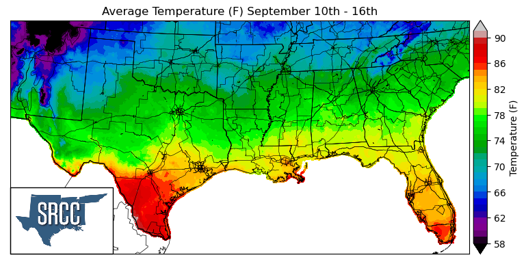
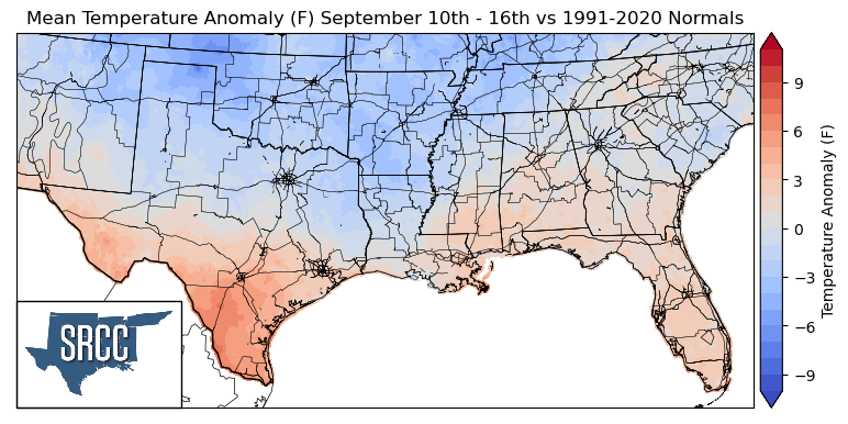
As September continues, Fall-like and seasonal temperatures are finally here for the southern climate region. A break in the high-pressure that was experienced much of the summer was replaced by low pressure and meridional flow last week . This brought below average and near normal temperatures to the majority of the region. Where temperatures were above normal in South Texas, daily average temperatures reached 90 degrees Fahrenheit. In contrast, in North Texas, Oklahoma, Arkansas, Louisiana, Mississippi, and Tennessee below and near-normal temperatures were experienced, leading to daily average temperatures ranging from 83 to 67 degrees Fahrenheit for the rest of the majority of the southern region.
Precipitation:
With the majority of the region being in a humid subtropical climate, rainfall is common at any point of the year. Frequently, during the fall months, cold fronts bring with them showers and thunderstorms. The boundary between the cold and warm air masses serves as a trigger mechanism for storms.
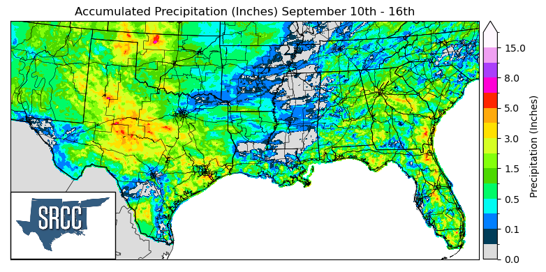
Last week's early week cold front, then sat along the Gulf coast as a stationary front, bringing with it thunderstorms as it moved through and showers as it sat along the coast. Also, the addition of upper level support from a pattern change favored severe thunderstorm development along the dryline in the Texas Panhandle. Thanks to all these lifting mechanisms, Texas, Oklahoma, Louisiana, and Western Arkansas were able to all receive widespread precipitation last week. Texas and Oklahoma saw the most rain last week with an average accumulated precipitation for the week of about 2.0 inches across the two states.
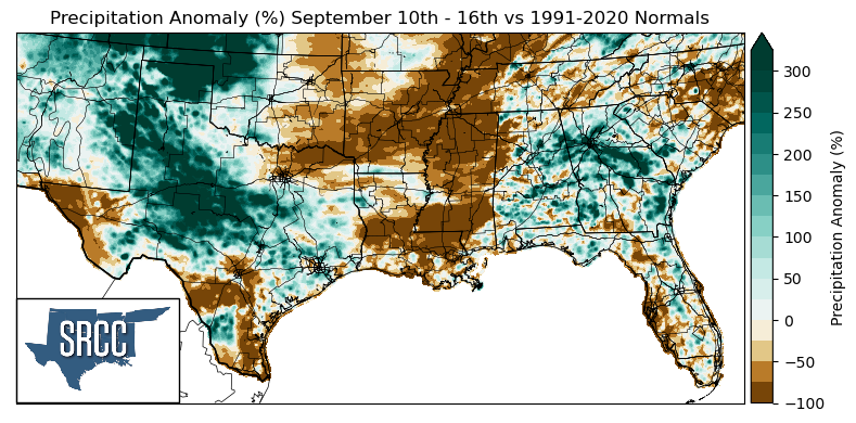
Unfortunately, not all of the climate region was lucky enough to receive widespread precipitation. When comparing precipitation totals last week to climatological normals, precipitation anomalies of -100% were experienced at a large scale in Arkansas, Mississippi, Central Louisiana, and Western Tennessee.
The areas that witnessed above-average precipitation compared to normal were primarily in Texas and Oklahoma. Some of the largest precipitation anomalies experienced were in Central Texas, the Texas Panhandle, and Western Oklahoma, where precipitation was about three times normal.
Records/Extremes:
- 9/11/2023: Goodnight, TX: 77 mph wind gust associated with a severe thunderstorm
- 9/12/2023: Cross Plains, TX: 1.75 inch hail
- 9/14/2023: Hidden Mesa, TX: 3.88 inches of rain via CoCoRaHS submission
- 9/14/2023: Near Alton, LA: 3.06 inches of rain via CoCoRaHS submission
- 9/16/2023: La Villa, TX: Landspout Tornado