8/27/2023 - 9/02/2023
Climate in the News:
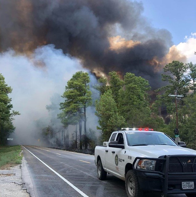
On Friday, September 1st, a large fire erupted in Walker County, Texas, growing 10 times its size in a matter of three hours. As of September 3rd, the fire has grown to an estimated 4,428 acres and is 60% contained. “The cause of the fire is still unknown, but drought conditions have made the fire’s spread extreme”, officials said. Walker County is currently under a burn ban along with 213 other Texas counties. It is important to practice fire weather safety when under a burn ban, or when under red flag warnings. Outlined by the National Weather Service, one can practice fire weather safety by: avoiding all fire-related activities, not starting a campfire or burning grass, using caution when working with machinery that might spark, checking chain bearings and exhaust systems, avoiding parking on dry grass, obeying burn bans, and reporting any fires to local officials.
Weather Synopsis:
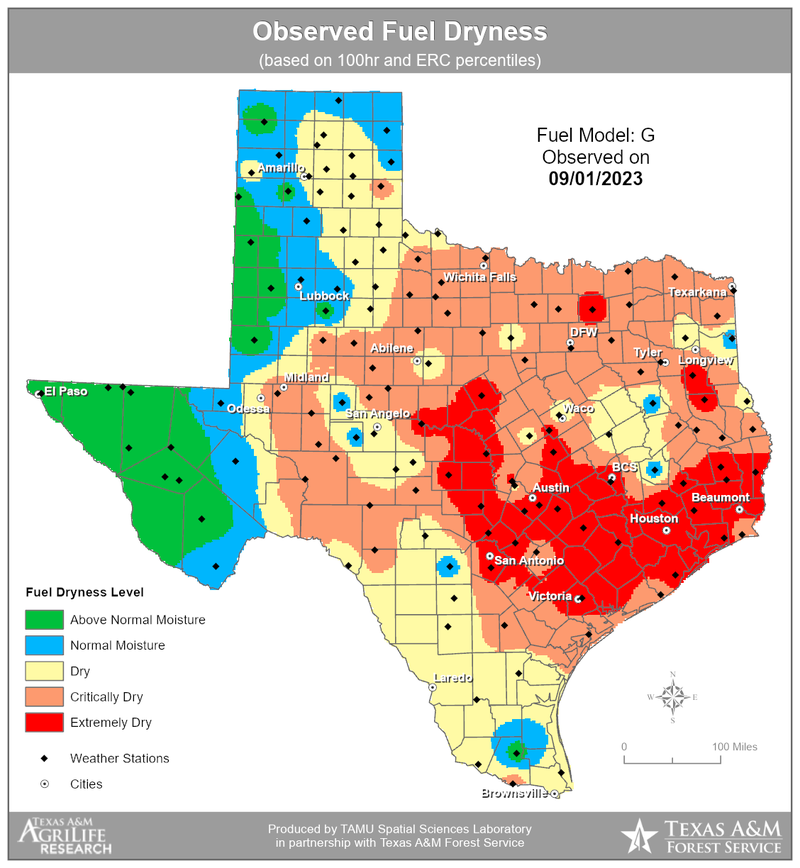
Conditions aided in the spread of this fire. Walker County is currently experiencing D3 drought conditions (extreme drought), which provided the fire with an ample amount of fuel to facilitate its growth. Weather conditions also played a role in enhancing this fire. Despite calm winds, the relative humidity at a nearby station in Huntsville, TX, at 2 pm on September 1st was 27%, and anything below 25% meets the criteria for a red flag warning. The air temperature at that time stood at 99 degrees Fahrenheit. While the parameters did not fully meet the criteria for a red flag warning, a fire was still able to ignite and spread rapidly.
Temperature:
Overall, summer days in August are hot across most of the region. It is hot both during the day and at night for most areas, with high humidity levels near the coast due to the prevailing southerly winds that bring moisture from the Gulf of Mexico.
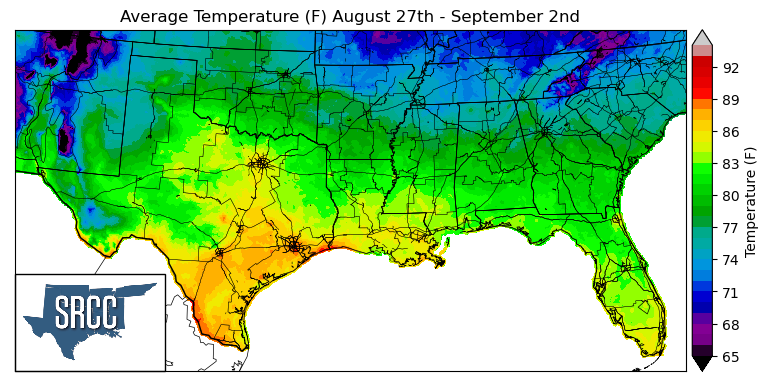
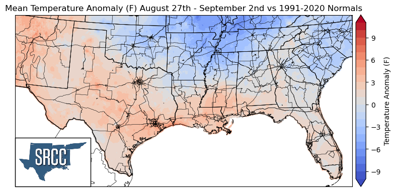
This past week brought a glimpse of fall, as the week started off with a frontal passage through the region, bringing with it more seasonable temperatures. Daily average temperatures for the week reached as high as 89 degrees Fahrenheit in Houston, cooler than the previous week's 92 degrees Fahrenheit. Texas, Louisiana, and Southern Mississippi experienced normal to at most 4 degrees above average temperatures last week,while Oklahoma, Arkansas, Tennessee, and Northern Mississippi experienced temperatures below normal. The largest departures from normal were experienced in Northeastern Arkansas and Northwest Tennessee where temperatures were 5 degrees Fahrenheit below normal. This all resulted in daily average temperatures ranging from 84 to 68 degrees for the Northern states of the climate region.
Precipitation:
With the majority of the region being in a humid subtropical climate, rainfall is common at any point of the year. Frequently, during the summer months, sea breezes initiate thunderstorms and rain showers, which are quite common along the coastal areas.
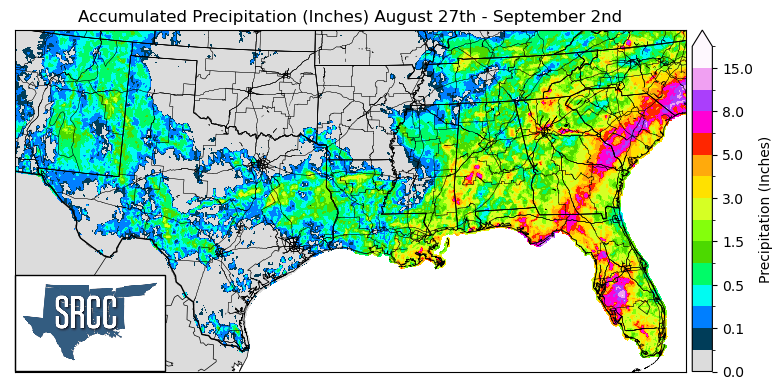
Last week's frontal passage brought some much-needed showers to parts of Texas and Louisiana and evening pop-up thunderstorms led to widespread precipitation in parts of Tennessee and Mississippi. Thanks to this frontal boundary and the storms it produced, the drought-stricken state of Louisiana was able to get some much-needed rainfall, with the state averaging 1.0 inches of accumulated precipitation and an extreme of 6.0 inches for the week near Houma, LA.
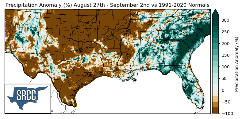
The areas that witnessed above-average precipitation compared to normal were concentrated in Central Texas, Eastern Mississippi, and Northeast Tennessee. These areas experienced precipitation anomalies that were 200% greater than normal last week.
Many areas of Texas, Western Mississippi, Arkansas, and Oklahoma remained dry in the past few weeks. As a result, large portions of Texas, Western Mississippi, Arkansas, and Oklahoma experienced precipitation anomalies of around -100%.
Records/Extremes:
- 8/27/2023: Gulfport, MS: Wind gust of 81 mph
- 8/27/2023: Houston, TX: Tied all-time record high, with high temperature of 109°F
- 8/27/2023: Lacombe, LA: 1.75 inch hail
- 8/29/2023: Lubbock, TX: Landspout
- 8/29/2023: Crossville, TN: Set a new daily rainfall record at 3.24 inches