8/13/2023 - 8/19/2023
Climate in the News:
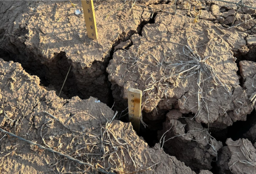
As one of the hottest summers on record continues for Texas, Louisiana and Southern Mississippi, drought conditions are continuing to worsen all across the southern region. As many areas continue to experience above average temperatures and below average precipitation, wildfires continue across Texas, Louisiana, and Mississippi, 200 out of 254 Texas counties have issued a burn ban, and Louisiana issued a statewide burn ban earlier this month. Precipitation this summer has been nearly 50% below normal for much of the two states. This lack of precipitation has not only fueled drought and wildfires, but it has also led water restrictions in many areas. As of the 19th, Lake Travis and Lake Buchanan, both outside of Austin, TX, which provide fresh drinking water for over 1.4 million people, are currently sitting at a combined 45% full. Water supply issues have led cities in central Texas to announce Stage 2 water restrictions. To read more about drought conditions in the southern plains, please read the Southern Plains Drought Update.
Weather Synopsis:
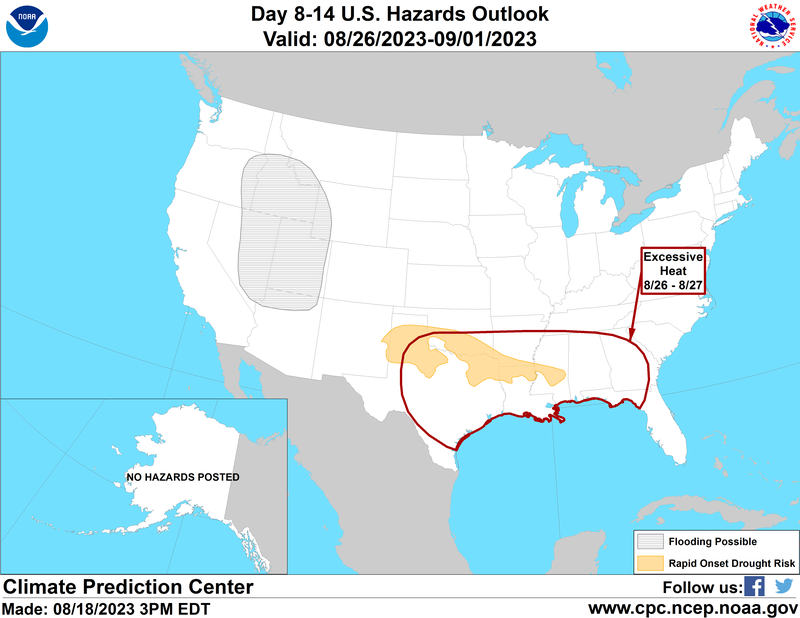
Flash drought conditions are expected toward the end of the month in the Texas Panhandle, Southern Oklahoma, Northeast Texas, Northern Louisiana/Southern Arkansas, and Central Mississippi. Excessive heat risks for the end of the month incorporate almost the entirety of the southern climate region. For the remainder of the month of August, these regions also coincide closely with areas where precipitation is forecasted to be below normal. The Climate Prediction Center has outlined the tri-state ArkLaTex region, having 40-50% below-normal precipitation anomalies in the 6-10 Day Precipitation Outlook.
Temperature:
Overall, summer days in August are hot across most of the region. It is hot both during the day and at night for most areas, with high humidity levels near the coast due to the prevailing southerly winds that bring moisture from the Gulf of Mexico.
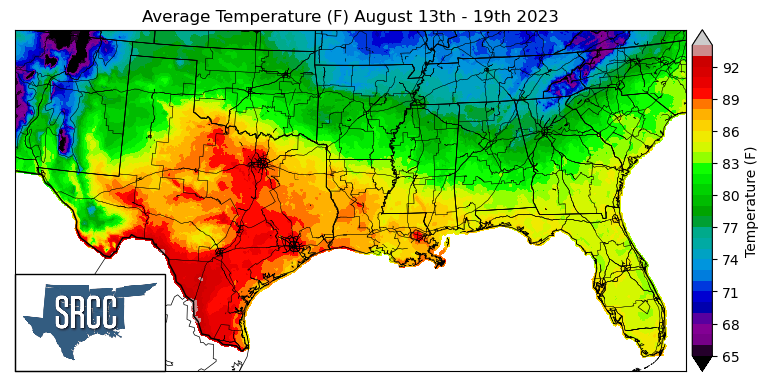
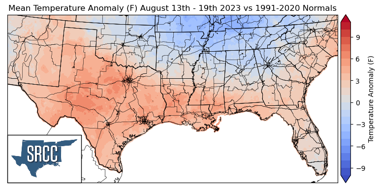
As the month of August continues, it brings along ongoing excessive heat warnings, advisories, and the risk of wildfires. A high-pressure center was situated over South Texas toward the end of the week, bringing further above-average temperatures to Texas and Louisiana. Daily average temperatures reached as high as 95 degrees Fahrenheit in some areas along the Texas-Mexico border. Texas and Louisiana observed the warmest temperatures last week, with much of the two states experiencing daily average temperatures ranging from 86 to 92 degrees. Nearly the entire southern portion of the climatic region encountered above-average temperatures last week, with anomalies ranging from 9 degrees higher than normal in North Central Texas to 4 degrees above normal in southern Mississippi.
While half of the region was experiencing above-average temperatures, Oklahoma, Arkansas, Tennessee, and northern Mississippi enjoyed temperature anomalies from near normal in Central Oklahoma to 4 degrees below normal in Northwest Tennessee. This resulted in daily average temperatures ranging between 72 and 86 degrees Fahrenheit for these states.
Precipitation:
With the majority of the region being in a humid subtropical climate, rainfall is common at any point of the year. Frequently, during the summer months, sea breezes initiate thunderstorms and rain showers, which are quite common along the coastal areas.
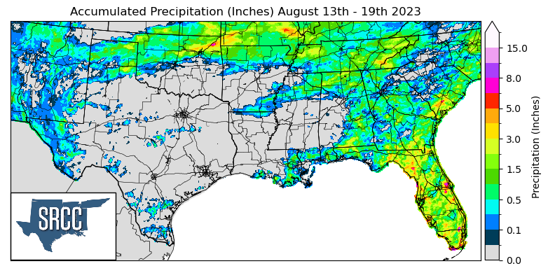
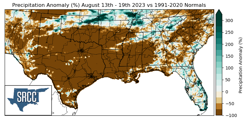
Precipitation was relatively scarce across the climatic region last week; the only state that had widespread precipitation was Tennessee. Due to frequent showers throughout the week across the northern portion of the region, accumulated precipitation totals for the week averaged about 1.0 inch in these areas, reaching as high as 6.5 inches in Northern Oklahoma.
The areas that witnessed above-average precipitation compared to normal were Northeast Oklahoma and Northwest Tennessee. Both areas experienced precipitation anomalies that were 250% greater than normal last week.
Many areas of Texas, Louisiana, and Mississippi remained dry in the past few weeks, with the addition of Arkansas last week. As a result, the majority of Texas, Louisiana, Mississippi, Arkansas, and Southern Oklahoma experienced precipitation anomalies of around -100%.
Records/Extremes:
- 8/13/2023: Shreveport, LA: New record high temperature set at 106°F
- 8/13/2023: Arnett, OK: 70 mph wind gust associated with a severe thunderstorm
- 8/13/2023: Benton County, AR: 3.37 inches of rain via CoCoRaHS submission
- 8/15/2023: Brownsville, TX: Landspout Tornado
- 8/16/2023: Austin, TX: 40 straight days of 100°F or hotter