7/9/2023 - 7/15/2023
Climate in the News:
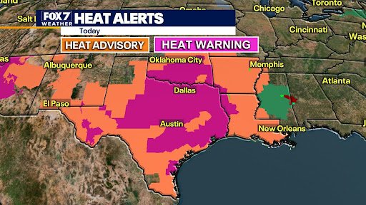
As prolonged heat waves continue through this summer, bringing along with them many heat advisories and heat warnings, news outlets have started using the term "heat dome." But what really is a heat dome? In the words of the Texas State Climatologist, Dr. Nielsen-Gammon, “A heat dome is an area of high pressure on the equatorward side of the jet stream that extends several miles up into the atmosphere. Typically it will be 1000-2000 miles across and move slowly. Air inside of it has descended and is relatively warm, and when it occurs over Texas, it also ingests hot dry air from the elevated terrain of northern Mexico and the desert southwest. At ground level, the heat dome inhibits thunderstorm development and maximizes absorption of energy from the Sun. Air near the ground heats up from the Sun and mixes with hot air aloft to make things even hotter.”
Weather Synopsis:
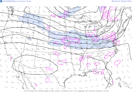
To visualize and understand how it is impacting the weather in the southern region of the United States, looking at upper-level winds and pressure can be helpful. Centered over Arizona and New Mexico, there is a closed 9780-meter height contour. Higher heights correspond to higher pressures, so this can be analyzed as a high-pressure center. That area is also evident of high pressure due to the anticyclonic or clockwise turn of the winds around the pressure center.
Temperature:
Overall, summer days in July are hot across most of the region. It is hot both during the day and at night for most areas, with high humidity levels near the coast due to the prevailing southerly winds that bring moisture from the Gulf of Mexico.
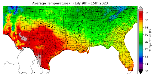
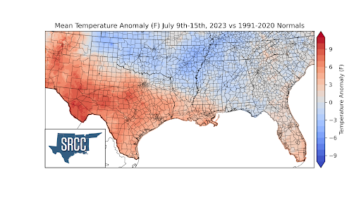
Extreme heat watches, warnings, and advisories were back last week in Texas and areas of Southern Louisiana as a large upper-level ridge parked itself over New Mexico for much of the week. Because of this, some of the warmest temperatures were seen in Texas, where areas of South Texas and far west Texas saw daily average temperatures of about 95 degrees Fahrenheit. This resulted in temperature anomalies in the area being as much as 9 degrees warmer than normal. However, the rest of the region saw unusually cool temperatures, with temperature anomalies being 0-3 degrees Fahrenheit below normal and daily average temperatures between 76 to 82 degrees Fahrenheit.
Precipitation:
With the majority of the region being in a humid subtropical climate, rainfall is common at any point of the year. Frequently, during the summer months, sea breezes initiate thunderstorms and rain showers, which are quite common along the coastal areas.
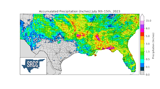
Pop-up showers and thunderstorms were common across the northern part of the region, where the necessary ingredients for thunderstorms were plentiful. Areas in Southern Arkansas and Eastern Mississippi saw precipitation accumulations of up to 10.0 inches over the past week, leading to flash flooding events in both areas. Taking a broader scale, precipitation was relatively widespread across the region last week, leading to an average accumulated precipitation amount of 1.5 inches.
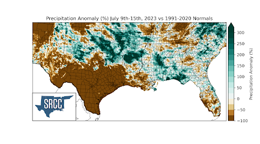
Much of Southern Arkansas and Western Mississippi experienced precipitation anomalies 250% greater than normal. While Southern/Central Oklahoma, Arkansas, and some of Northern Louisiana also experienced above-average precipitation anomalies with values around +200%.
While overall precipitation was widespread across the region, a large portion of Texas did not see any precipitation accumulations last week. This resulted in precipitation anomaly values 100% below normal in central, west, and south Texas.
Records/Extremes:
- 7/09/2023: Bethany, OK: 2.75 inch hail
- 7/11/2023: Wolfforth, TX: 76 mph winds
- 7/12/2023: Stamps, AR: EF 1 Tornado
- 7/12/2023: Buckner, AR: 8.45 inches of rain via CoCoRaHS
- 7/14/2023: Scooba, MS: 5.67 inches of rain via CoCoRaHS