7/30/2023 - 8/5/2023
Climate in the News:
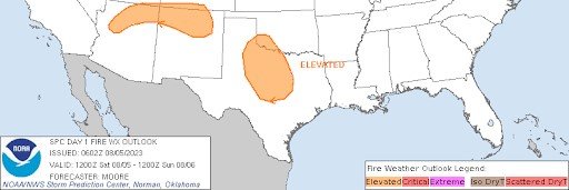
Below is a photo of the Oak Grove Fire in Hays County, Texas, on Saturday evening. As of Sunday morning, the fire had reached 400 acres and was nearly 20% contained. Smoke plumes from the fire could even be seen on visible satellite imagery on Sunday morning. As drought conditions continue to worsen across the state of Texas as summer continues, and the state enters its wildfire season (August - October), the majority of Hays County is currently experiencing D3 or Extreme Drought conditions. This is evident by looking at the foreground in the picture below, where there is an abundance of dead grass to fuel this fire.

Weather Synopsis:
Not only did the fire have abundant fuel to help it spread, strengthen, and ignite, but weather conditions were also conducive to the formation and spread of this fire. Saturday was a particularly hot day across the southern region. Austin, Texas, only one county over, experienced a record-setting daily high temperature of 106°F. Hays County was also under a red flag warning on Saturday, meaning that there was abundant fuel for a fire, the relative humidity was less than 25%, indicating very dry air, and finally, winds 20 feet off the ground were at least 15 mph for several hours. At a nearby station on Sunday, winds were reported to be gusting up to 35 mph. For more information on fire weather, visit the weekly summary from the week of 6/25/23.
Temperature:
Overall, summer days in August are hot across most of the region. It is hot both during the day and at night for most areas, with high humidity levels near the coast due to the prevailing southerly winds that bring moisture from the Gulf of Mexico.
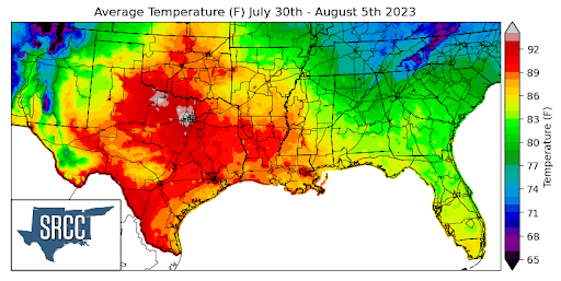
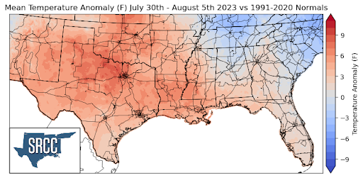
As this prolonged heatwave continues into the month of August, unfortunately, excessive heat warnings and advisories persist as well. A high-pressure center was situated for much of the week over East Texas and Louisiana, bringing with it further above-average temperatures to the majority of the climatic region. Daily average temperatures reached as high as 95 degrees Fahrenheit in areas of North Texas. Texas, Louisiana, and Oklahoma observed the warmest temperatures last week, with much of the three states experiencing daily average temperatures in the 90s. Nearly the entire climatic region encountered above-average temperatures last week, except for Tennessee, where anomalies ranged from 9 degrees higher than normal in North Texas to 3 degrees above normal in central Mississippi.
While many states experienced positive temperature anomalies, Tennessee enjoyed temperature anomalies as low as 4 degrees Fahrenheit below normal, resulting in daily average temperatures ranging between 70 and 82 degrees Fahrenheit for the state.
Precipitation:
With the majority of the region being in a humid subtropical climate, rainfall is common at any point of the year. Frequently, during the summer months, sea breezes initiate thunderstorms and rain showers, which are quite common along the coastal areas.
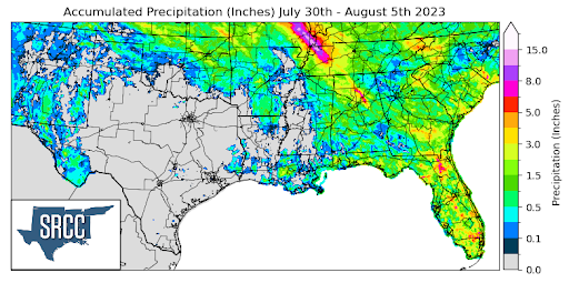
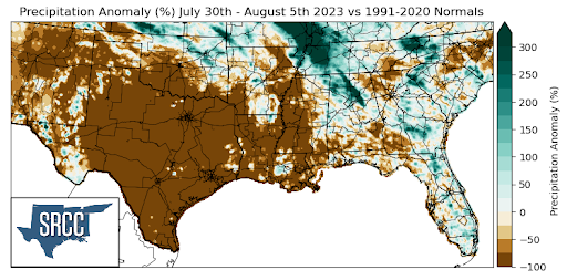
Pop-up showers and severe thunderstorms were widespread across the state of Tennessee and other northern portions of the region, namely Oklahoma and Arkansas, last week. Due to these frequent storms throughout the week, accumulated precipitation totals for the week averaged about 2.0 inches across Tennessee, reaching as high as 10.0 inches in some areas. Taking a broader perspective, precipitation in the region last week was heavily concentrated in one or two states, resulting in an average accumulated precipitation of 0.1 inches for the entire region.
The regions that witnessed above-average precipitation compared to normal were Western Tennessee, where precipitation anomalies were 300% greater than normal.
Many areas of Texas, Louisiana, and Mississippi remained dry last week. Consequently, the majority of Texas, Louisiana, and Western Mississippi experienced precipitation anomalies of around -100%.
Records/Extremes:
- 7/31/2023: Pascagoula, MS: 61 mph winds
- 8/3/2023: Bradbury, TN: Report of brief tornado touchdown
- 8/5/2023: Monroe, LA: Record daily high temperature of 104°F
- 8/5/2023: Amarillo, TX: 1.25 inch hail
- 8/5/2023: Del Rio, TX: Record daily high temperature of 109°F