7/2/2023 - 7/8/2023
Climate in the News:
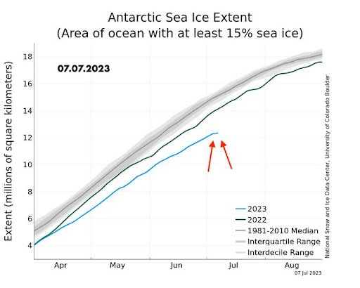
Not only has the Southern Climate Region been experiencing above-average temperatures this summer, but so has the Antarctic. In the past, at this time of year, about 15 million square kilometers of the Antarctic Sea would be covered by 15% sea ice. This year, a record minimum has been reached, with only about 12.3 million square kilometers of sea covered in sea ice. While Antarctic sea ice extent has been widely variable over the past several years, it can be observed that over time a downward trend is occurring. It is still being researched why this is happening exactly. However, it is known that when water freezes, it condenses, so when it melts, the opposite occurs. All this melting ice is going into the ocean, causing rising sea levels, which will eventually have a drastic impact on coastal communities.
Weather Synopsis:
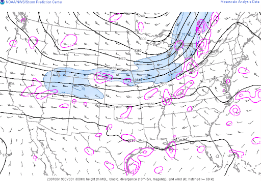
Dominating much of the weather pattern last week was zonal flow in the upper-level wind patterns. Simply put, this means the majority of the upper-level winds were moving west to east. During meridional flow, large-scale troughs and ridges are in place, which can enhance storms depending on their positioning in the jet stream. Without large-scale ridging taking place last week, hindering thunderstorm development, boundary intersection, and sea breezes were able to initiate thunderstorms across the region.
Temperature:
Overall, summer days in July are hot across most of the region. It is hot both during the day and at night for most areas, with high humidity levels near the coast due to the prevailing southerly winds that bring moisture from the Gulf of Mexico.
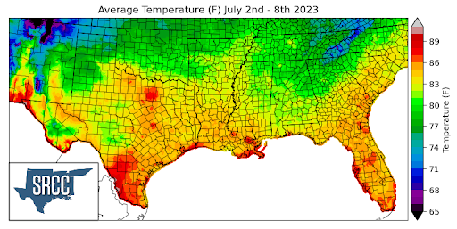
While heat advisories were still present in the southern region last week, compared to previous weeks, temperatures were much milder. The milder temperatures were due to a break in the upper-level ridging that has dominated the weather pattern for weeks now. On the hotter end, some regions of Texas saw daily average temperatures between 92 and 86 degrees Fahrenheit. Overall, the region's daily average temperatures ranged between 85 and 82 degrees Fahrenheit. However, higher altitude regions such as the Great Smoky Mountains in Eastern Tennessee experienced daily average temperatures around 71 degrees Fahrenheit due to their elevation.
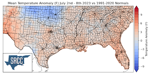
Comparing all these temperatures to the normal averages, we can observe that the majority of the climate region saw temperature anomalies of about 4 to zero degrees above normal, showing just how milder the temperatures were this week compared to last week when, in some areas, temperature anomalies were 12 degrees above normal. Last week, Oklahoma saw some below-average temperatures, with the state having temperature anomalies of 1 to 5 degrees below normal.
Precipitation:
With the majority of the region being in a humid subtropical climate, rainfall is common at any point of the year. Frequently, during the summer months, sea breezes initiate thunderstorms and rain showers, which are quite common along the coastal areas.
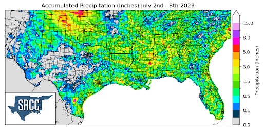
As discussed above, with relatively zonal flow last week, small-scale lifting mechanisms were able to trigger afternoon and evening thunderstorms across the region. Areas in the Texas and Oklahoma Panhandles saw precipitation accumulation of up to 6.5 inches over the past week. Taking a broader scale, precipitation was relatively widespread across the region last week, leading to an average accumulated precipitation amount of 1.0 inches.
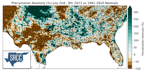
Much of Oklahoma and the northern Texas Panhandle experienced precipitation anomalies 300% greater than normal. Many areas in Mississippi, Arkansas, and Northern Louisiana also experienced above-average precipitation anomalies with values around +200%.
While overall precipitation was widespread across the region, a large portion of Texas did not see any precipitation accumulations last week. This resulted in precipitation anomaly values 100% below normal in central and west Texas.
Records/Extremes:
- 7/3/2023: Bossier County, LA: 58 mph winds
- 7/3/2023: College Station, TX: Tied daily record minimum at 79°F
- 7/5/2023: Hemphill County, TX: 2.5 inch hail
- 7/7/2023: Sherman County, TX: Tornado
- 7/8/2023: Beaver County, OK: 3.70 inches of rain via CoCoRaHS