6/25/2023 - 7/1/2023
Climate in the News:
As wildfires in Canada continue to burn, the downstream air quality continues to be impacted. In Tennessee last week air quality indexes reached 154 in Chattanooga. Below is an image from Maryville, Tennessee, from June 29th. The hazy skies are due to the smoke produced by the wildfires in Canada. The smoke was able to be transported hundreds of miles due to a low-pressure system in the northeast, causing winds to come from the north and carrying the smoke with them. Breathing in this smoky air causes PM 2.5 particles to enter the lungs. While ongoing research is still being conducted, it is said to lead to systemic inflammation, which over time can result in chronic illnesses that may become life-threatening.

Weather Synopsis:
As depicted below, weather conditions conducive to wildfires include hot temperatures, high winds, and dry air/soil. For a fire to occur, there needs to be an abundance of available fuel, such as dead or dry shrubs. Due to a warming climate, the number of fire weather days is increasing in many areas. As regional drought conditions worsen, it is crucial to adhere to county burn bans, especially with fire weather season approaching on the horizon.

Temperature:
Overall, summer days in June are hot across most of the region. It is hot both during the day and at night for most areas, with high humidity levels near the coast due to the prevailing southerly winds that bring moisture from the Gulf of Mexico.
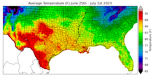
Extreme heat plagued much of the region last week. Both excessive heat warnings and heat advisories were issued in every state within the climate region. The extremely hot temperatures were due to a surface high pressure dominating the weather pattern for the entire week. Some regions of Texas saw daily average temperatures at or above 90 degrees Fahrenheit. Overall, the region's daily average temperatures ranged between 80 and 90 degrees Fahrenheit. However, higher altitude regions such as the Great Smoky Mountains in Eastern Tennessee experienced daily average temperatures around 70 degrees Fahrenheit due to their elevation.
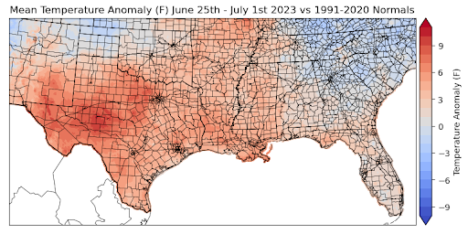
Comparing all these temperatures to the normal averages, we can observe that West Texas had temperature anomalies of about 6 to 12 degrees Fahrenheit above normal. The majority of the climate region, though, saw temperature anomalies of about 4 to 7 degrees Fahrenheit above normal. The only areas that were substantially colder than normal were the Oklahoma Panhandle and Eastern Tennessee.
Precipitation:
With the majority of the region being in a humid subtropical climate, rainfall is common at any point of the year. Frequently, during the summer months, sea breezes initiate thunderstorms and rain showers, which are quite common along the coastal areas.
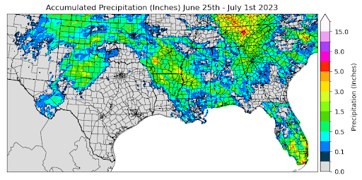
Last week was hot and dry yet again for much of the climate region. Popup showers were common in some areas, though, allowing some areas to receive some rain throughout the week. Several storm systems went through Tennessee last week allowing the eastern region to see accumulations up to 8.0 inches last week. Much of Texas, and parts of Oklahoma and Louisiana did not see any traceable amounts of precipitation last week. Overall, though, the average precipitation accumulation across the region was about 0.1 inches.
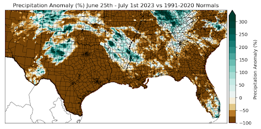
Eastern Tennessee, the Southern Texas Panhandle, and Central Arkansas experienced precipitation anomalies that were 200% greater than normal. Much of Texas, Oklahoma, Louisiana, and northern Arkansas, and Mississippi had precipitation values far below normal. Texas stayed particularly dry last week, resulting in precipitation anomalies 100% below normal for the majority of the state.
Regions that experienced some of the highest temperatures this week, such as South Texas, also experienced the driest conditions. Many of these regions didn’t even receive a trace of precipitation, resulting in anomaly values of -100% for those areas.
Records/Extremes:
- 7/1/2023: Davidson County, TN: 67 mph winds
- 6/29/2023: Lawrence County, TN: 2.75 inch hail
- 6/27/2023: Adams, OK: Tornado
- 6/28/2023: San Angelo, TX: daily record high temperature at 112 degrees