6/18/2023 - 6/24/2023
Climate in the News:
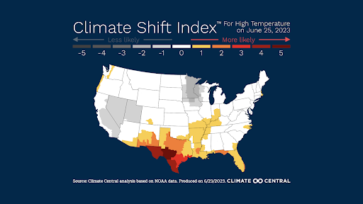
As climate change continues to impact the globe, temperatures are rising. As of 2022, about 1 degree Celsius of average global warming has occurred. With a warming planet, extreme heat events are becoming more and more common. Not only are these events more common, but new levels of heat are now possible which were not possible in a previously colder climate. Looking at the image below, we can see that on Sunday, June 25th, the high temperatures recorded are up to 5 times more likely to occur due to climate change. Inside this region is Del Rio, Texas. On June 25th, they broke a record from 1994 by 4 degrees, hitting 110 degrees Fahrenheit, although other nearby stations were not quite as hot. The excessive heat that has plagued much of the southern plains is enhanced by a warming global climate.
Weather Synopsis:
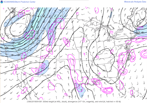
The black lines in the image below represent lines of constant pressure in the upper atmosphere. Right over Texas and up to the plains, an inverted “V” is created by these lines. This indicates an upper-level ridge that is associated with high surface pressure and warm surface temperatures. This high pressure has been referred to as a “heat dome” and it parked itself over Texas for the majority of last week. Due to this high pressure system sitting over the region, it also led to continued surface winds from the south, bringing warm, moist air, all contributing to the high heat indices last week.
Temperature:
Overall, summer days in June are hot across most of the region. It is hot both during the day and at night for most areas, with high humidity levels near the coast due to the prevailing southerly winds that bring moisture from the Gulf of Mexico.
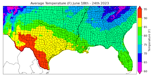
Excessive heat plagued much of Texas and Louisiana and will continue into this week in Texas and Oklahoma. The extremely hot temperatures were primarily concentrated in the lower latitudes of the region, specifically in Texas and Louisiana, with average temperatures at or above 85 degrees Fahrenheit for much of the two states. Some locations in southwest Texas experienced weeklong average temperatures that were hotter than any previously-recorded seven-day period. Areas such as the Texas Panhandle, Oklahoma, Arkansas, and Mississippi experienced average temperatures last week ranging between 75 and 80 degrees Fahrenheit.
On the other hand, the Oklahoma Panhandle, Northern Mississippi, and Tennessee remained relatively cool, with average temperatures ranging between 70 and 75 degrees Fahrenheit. In some areas with higher terrain, temperatures even dropped as low as 65 degrees Fahrenheit locally.
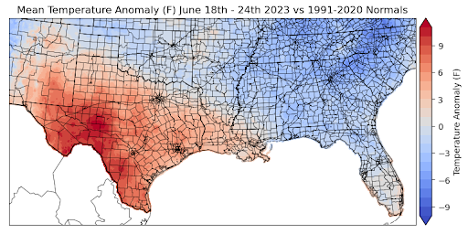
Comparing all these temperatures to the normal averages, we can observe that Southwest Texas had temperature anomalies of about 6-12 degrees Fahrenheit above normal. In contrast, most of the rest of the climate region, including Oklahoma, Arkansas, Mississippi, and Tennessee, experienced temperatures 0-4 degrees Fahrenheit below normal.
Precipitation:
With the majority of the region being in a humid subtropical climate, rainfall is common at any point of the year. Frequently, during the summer months, sea breezes initiate thunderstorms and rain showers, which are quite common along the coastal areas.
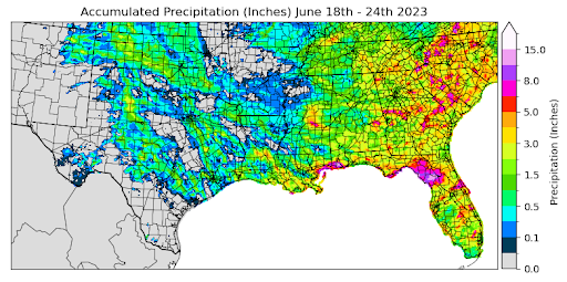
Hot and dry are two words that paint the picture for last week's weather conditions. Isolated storms were common in the evening, though, allowing some areas to receive some rain throughout the week. The highest areas of accumulated precipitation were seen along the Mississippi and Louisiana coastline due to sea breeze-initiated storms. Areas along the Mississippi coast received as much as 8.0 inches of rain in some places. Overall, though, the average precipitation accumulation across the region was about 0.75 inches.
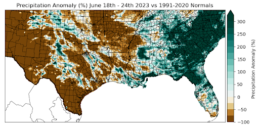
When compared to precipitation normals, Central Mississippi and the Mississippi coast experienced precipitation anomalies that were 250% greater than normal. Much of Oklahoma, Arkansas, Louisiana, and Texas had precipitation values far below normal. Oklahoma, Texas, Arkansas, and Louisiana stayed particularly dry last week, resulting in precipitation anomalies 50-100% below normal.
In terms of temperature and precipitation comparison, regions that experienced some of the highest temperatures this week, such as South Texas and West Texas, also experienced the driest conditions. Many of these regions didn’t even receive a trace of precipitation, resulting in anomaly values of -100% for those areas.
Records/Extremes:
- 6/18/2023: Yell County, AK: 71 mph winds
- 6/18/23: Rogers County, OK: EF 1
- 6/20/23: Del Rio, TX hit a record high of 113°F
- 6/21/23: Rapides County, LA: 3.5 inch hail
- 6/22/23: San Angelo, TX: tied previous record of 107°F
- 6/22/23: Matador, TX: EF 3 Tornado
- 6/23/23: Jackson County, MS: CoCoRaHS report of 5.63 inches of rain