6/11/2023 - 6/17/2023
Climate in the News:
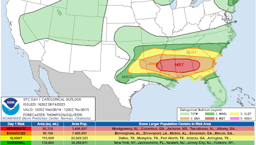
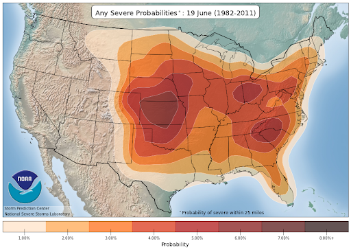
Last week, some abnormally timed severe weather broke out in the southern United States. Normally, at this time of year, as displayed by the lower image, severe weather tends to be concentrated in the central to high plains. So, why was there a moderate risk for severe weather last Wednesday in Dixie Alley, which normally sees its greatest risk for severe weather in the early spring? This June is characterized by a lot of unique climatological aspects that we are seeing impact the weather. For starters, we have the ongoing effects of climate change, which are seen to make the jet stream more wavy, possibly leading to more intense severe weather events. Secondly, we are entering the El Niño phase of ENSO, which enhances the subtropical (southern) jet stream.
Weather Synopsis:
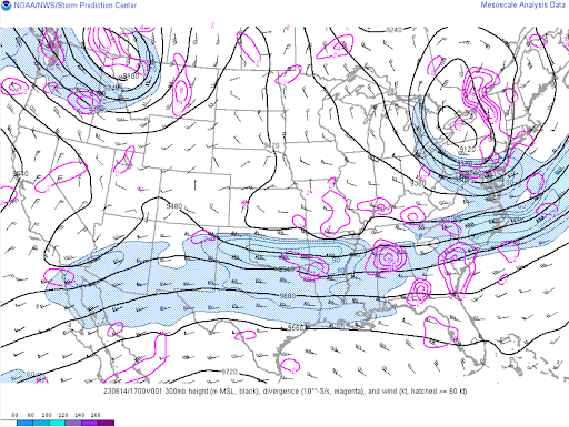
Depicted in the image below is the subtropical jet stream (the area shaded in blue). The presence of a jet stream can enhance the severe weather threat for two reasons. First, jet streams can provide the lifting mechanism necessary for thunderstorms to form. Secondly, a jet stream represents an enhanced region of strong upper-level winds. Thunderstorms require these strong upper-level winds in order to grow and sustain themselves. Therefore, without a jet stream present, it is much harder for storms to become severe. The enhancement of the subtropical jet stream is part of the reason why this anomalous late-season severe event occurred.
Temperature:
Overall, summer days in June are hot across most of the region. It is hot both during the day and at night for most areas, with high humidity levels near the coast due to the prevailing southerly winds that bring moisture from the Gulf of Mexico.
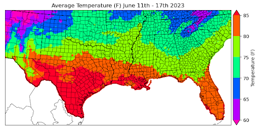
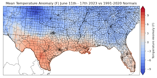
Excessive heat plagued much of the region over the weekend and will continue into this week. The extremely hot temperatures were concentrated in the lower latitudes of the region, specifically in Texas and Louisiana, with average temperatures at or above 85 degrees Fahrenheit for much of the two states. Areas such as north Texas, Southern Arkansas, and Central Mississippi experienced average temperatures last week ranging between 75 and 80 degrees Fahrenheit.
On the other hand, the Texas Panhandle, Oklahoma, Northern Arkansas, and Tennessee remained relatively cool, with average temperatures ranging between 70 and 75 degrees Fahrenheit. In some areas, average temperature for the week even dropped as low as 65 degrees Fahrenheit locally.
Comparing all these temperatures to the normal averages, we can observe that the lower latitude regions, specifically South Central Texas and Louisiana, had temperature anomalies of about 3-6 degrees Fahrenheit above normal. In contrast, the northern regions, including North Texas, Oklahoma, Arkansas, Mississippi, and Tennessee, experienced temperatures below normal.
Precipitation:
With the majority of the region being in a humid subtropical climate, rainfall is common at any point of the year. Frequently, during the summer months, sea breezes initiate thunderstorms and rain showers, which are quite common along the coastal areas.
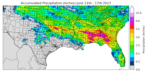
Due to the presence of the subtropical jet stream last week, thunderstorms were abundant throughout the region and this is displayed in accumulated precipitation. Areas in Central Mississippi and Northeast Texas saw precipitation accumulation of up to 8.0 inches over the past week. Taking a broader scale, the average precipitation accumulation across the region was about 1.0 inch.
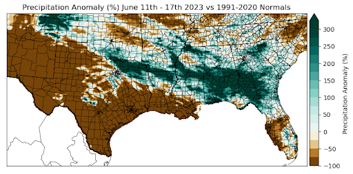
Northeast Texas, Northern Louisiana, and Mississippi experienced precipitation anomalies that were 300% greater than normal! Much of Oklahoma, Arkansas, and Tennessee had precipitation values around normal, while southern and eastern Texas experienced values far below normal.
Regions that experienced the highest temperatures this week, such as South Central Texas and Louisiana, also experienced the driest conditions. Many of these regions didn’t even receive a trace of precipitation, resulting in anomaly values of -100% for those areas.
Records/Extremes:
- 6/15/2023: Perryton, TX: EF 3 Tornado
- 6/16/2023: Fredericksburg, TX: 4 inch hail
- 6/16/2023: Norman, OK: 84 mph wind gust
- 6/17/23: Tulsa, OK, 70 mph winds
- 6/11/23: Jamestown, TN, Tornado
- 6/14/23: Brooksville, MS, 5+ inch hail
- 6/14/23: Titus County, TX, 3.35 in of rain