4/07/2024 - 4/13/2024
Climate in the News:
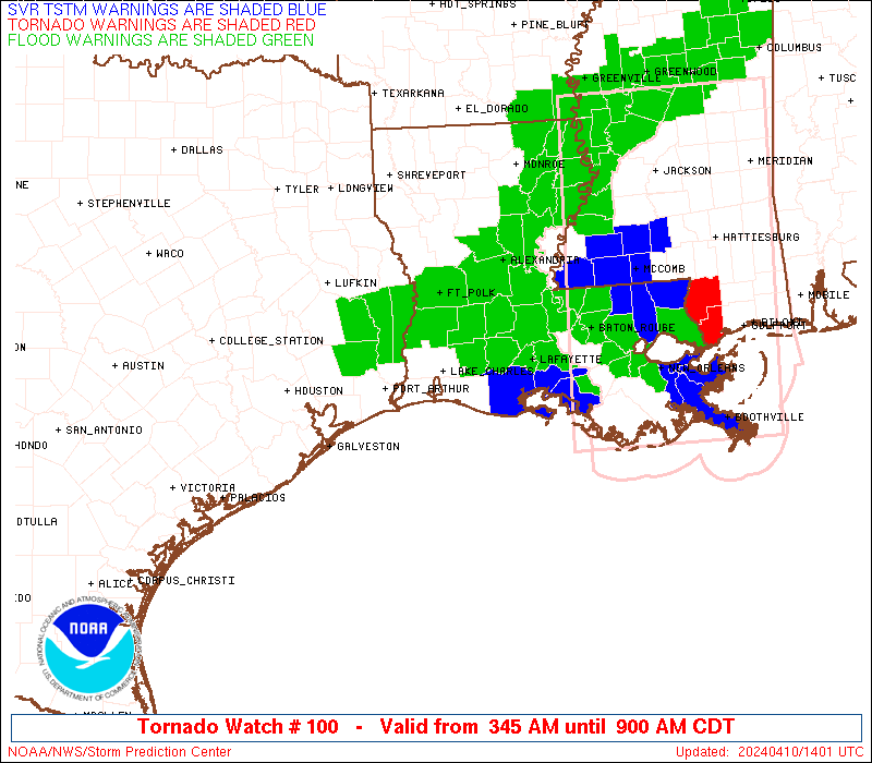
Damaging weather made its way through the Southern Region last week. In total, there were over 150 wind reports, 110 hail reports, and 18 tornados reported last week. Storms became most damaging as they moved through the Houston metropolitan area early Wednesday morning, dropping an EF-1 tornado in Katy, TX and damaging some businesses. As the storms moved into Louisiana and Mississippi on Wednesday, straight-line winds as the squall line arrived reached 70 mph in Baton Rouge, LA. This caused damage to many buildings, blowing off shingles, and blowing over many trees. Four people were injured in St. Landry Parish after a tree fell on a car. Before the system blew into Mississippi, the system dropped an EF-2 tornado that tracked through Slidell, Louisiana, damaging homes and businesses, but no injuries or deaths were reported.
Weather Synopsis:
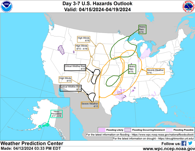
The Southern Region gears up for yet another week of active weather. As displayed on the map below, severe weather is anticipated today (Monday) from Northwest Texas into Oklahoma. As this low-pressure system moves northeast, severe weather tomorrow is forecasted from Northeast Texas into Arkansas. Along with this system, heavy rainfall is expected as well as flooding/flash flooding in Oklahoma, Texas, and Louisiana. Finally, the low-pressure system will bring high winds today, leading to a critical wildfire risk in far West Texas and part of the Texas Panhandle.
Temperature:
Overall, April is when the Region is starting to see consistently warmer temperatures. However, regular cold fronts are still common, bringing both rain chances and below-normal temperatures for a few days.
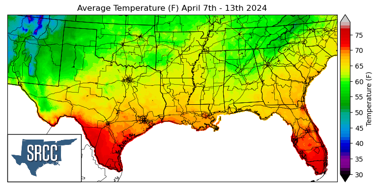
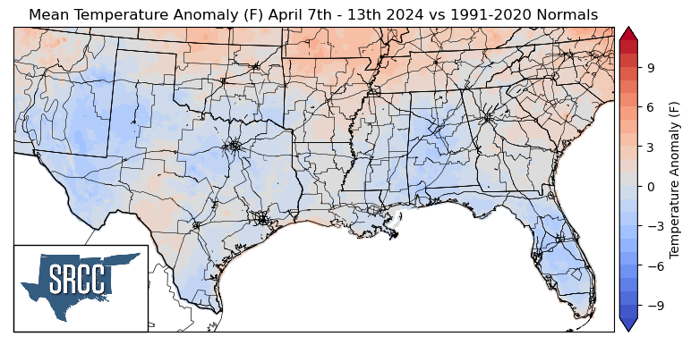
Temperatures were quite mild again this week in the Southern Region. In the higher latitude areas of the Region, weekly temperatures favored slightly above-normal, while further south temperatures were normal or slightly below-normal. Due to these mild temperatures, no significant departures from the weekly normal were observed. Overall average temperatures for the week ranged between 70 and 56 degrees Fahrenheit, with the lower bound of this being about 5 degrees warmer than the previous week.
Precipitation:
With the majority of the Region being in a humid subtropical climate, rainfall is common at any point of the year. During the spring months, storm systems are common throughout the south. During April severe storm probabilities are at their highest in Oklahoma and Northeast Texas.
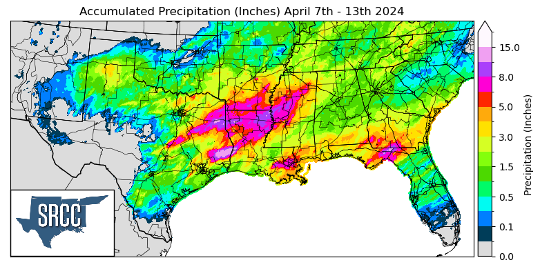
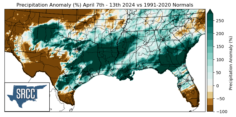
Precipitation was plentiful in the track of last week's storm system, but places such as West Texas and the Lower Rio Grande Valley remained dry. Flash flooding was a large issue from East Texas into Central Mississippi with this system as large amounts of precipitation fell in a very short period of time. Slidell, LA, received 2.10 inches of rain in just one hour, an all-time record for April. In Tyler County in East Texas, 12 inches of rainfall was reported via CoCoRaHS Wednesday. Rain totals were high on Tuesday as well with 5.76 inches of rain falling in Bienville Parish according to a CoCoRaHS report. Overall, weekly rainfall accumulation reached as high as 15 inches in Tyler County, TX, and most of northern Louisiana saw at least 8 inches.