11/26/2023 - 12/02/2023
Climate in the News:
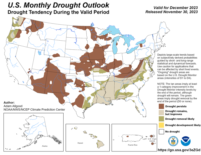
As the southern climate region enters December and meteorological winter, NOAA and NCEP have released a new Monthly Drought Outlook. Taking a detailed look at this, far West Texas, the Texas Panhandle, Central Texas, and Southwest Oklahoma can all expect drought to persist, as the Monthly Precipitation Outlook from the Climate Prediction Center only forecasts chances for above-normal precipitation from East Texas eastward through the region. Next, areas in the Lower Brazos Valley/Houston Area, as well as some areas in Northeast Texas and Central Arkansas can expect to see removal of drought conditions. Whereas in Louisiana, Mississippi, and parts of Tennessee drought is expected to improve yet remain, although in Northern Tennessee drought improvement is not expected. In the three states, a minimum of 6 inches of rainfall is required to ameliorate drought in Western Tennessee, while up to 20 inches is required in Southeast Louisiana.
Weather Synopsis:
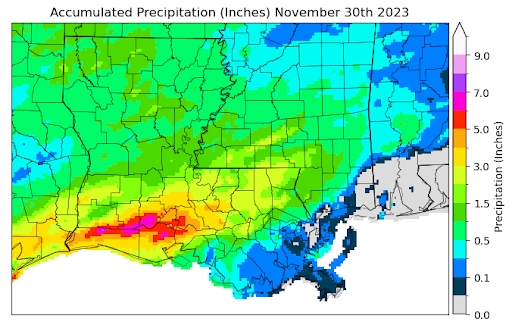
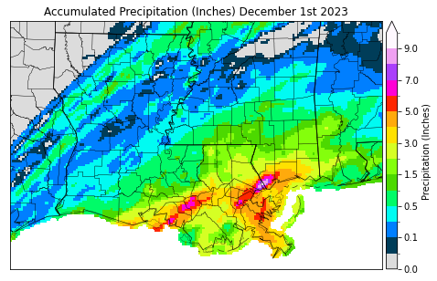
Below depicts two maps of Louisiana displaying the rainfall that occurred from Thursday night into Friday morning due to a squall line brought by an advancing cold front. Rain totals reached almost eight inches in the northern portion of Cameron Parish. While areas in southeastern Louisiana that need rain the most received up to ten inches along the Mississippi border of the Saint Tammany Parish. This significant rainfall should help to improve drought conditions in the area.
Temperature:
Overall, November is when most of the region starts to see temperatures cooling down significantly. Frequent cold fronts bring with them colder air masses from the north.
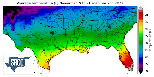
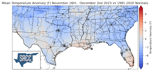
A cold front swept through the southern region Thursday into Friday leaving behind cool and dry conditions for the Southern Region. Due to this strong cold front, temperatures were normal all across the central plains into the southern region, but warmer conditions proceeding the front made for a weekly average near normal in some areas of Texas, Louisiana, and Mississippi. Daily average temperatures for the week were about 6 degrees Fahrenheit below normal in the Panhandle region, kicking off a meteorological winter with some chilly temperatures. Some of the coldest temperatures were reported in the Oklahoma Panhandle where the weekly daily average temperature was about 35 degrees. The temperature for the majority of the region ranged between 60 and 40 degrees Fahrenheit.
Precipitation:
With the majority of the region being in a humid subtropical climate, rainfall is common at any point of the year. Frequently, during the fall months, cold fronts bring with them showers and thunderstorms. The boundary between the cold and warm air masses serves as a trigger mechanism for storms.
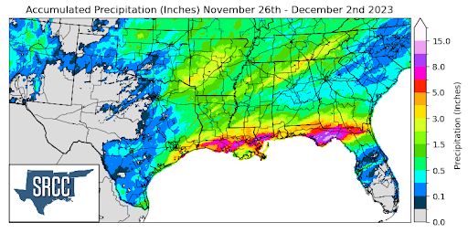
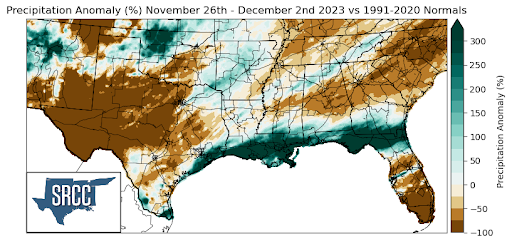
The majority of the precipitation seen last week was due to a surface low-pressure system that moved from North-Central Texas into Oklahoma Thursday night. This low-pressure system brought with it associated cold and warm fronts, to the region leading to heavy rain and thunderstorms. However, most precipitation from this system was thanks to the cold front as it advanced along the Gulf states. These storms mainly brought heavy rain as flash flood warnings were issued for Southern Louisiana and Southern Mississippi Thursday night. This brought more much-needed rain to a swath of exceptional drought (D4) along the Louisiana coast, with the entire coast seeing weekly precipitation totals three times normal.
Records/Extremes:
- 12/1/2023: Labadieville, LA: Gold ball size hail associated with a severe thunderstorm
- 12/1/2023: Poparville, MS: Brief EF-0 Tornado
- 12/1/2023: Near Deatonville, LA: 7.70 inches of rain via CoCoRaHS submission