1/07/2024 - 1/13/2024
Climate in the News:
A strong cold front last week left the Southern Region quite chilled to start off this week. Snow is on the ground across the region from Texas, Oklahoma, and Northern Louisiana to Arkansas and Tennessee.Winter storm warnings and advisories were issued across the region. Coupled with high winds wind chill warnings and advisories were issued, as wind chills in North Texas and Oklahoma were below zero degrees and we can't forget about the cold where nearly all of the southern region is under a hard freeze warning. It is important during weather like these to remember to protect people, pets, and property.
Weather Synopsis:
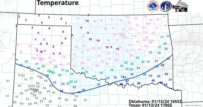
Denoted by the blue line on the map below the cold front responsible for bringing this arctic air to the Southern Region can be seen moving southward through the Texas panhandle and Oklahoma on Saturday around 11 am. As it moved through Oklahoma not only did it bring temperatures below freezing but it also brought wind chills below zero degrees Fahrenheit.
Temperature:
Overall, January is when the Region is consistently seeing cooler temperatures. Frequent cold fronts bring with them colder air masses from the Rocky Mountains and Canada, bringing freezing temperatures to the northern portions of the region.
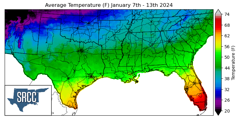
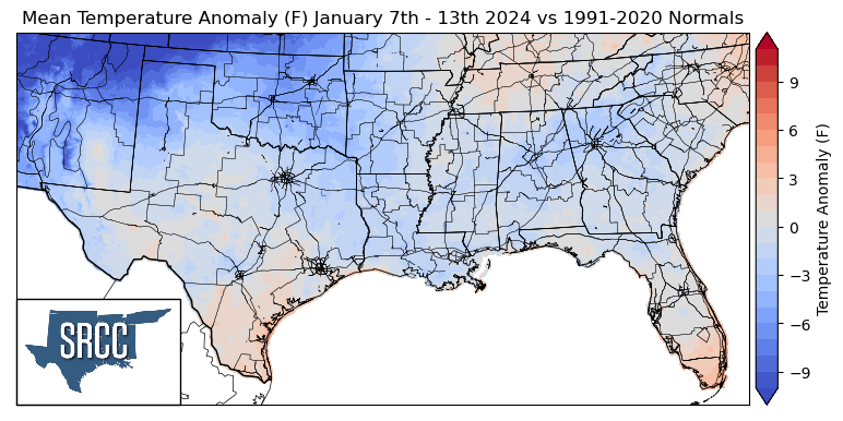
The week began with relatively warm temperatures until on Monday a weak cold front swept through the Region, but by Wednesday moisture and southerly winds from the Gulf had already returned. Temperatures would remain warm until a cold front Friday made it through the region, with a stronger Arctic air mass following Saturday's front. Overall weekly average temperatures for the Region were slightly below normal in most places, with the largest departure from normal occurring in the Oklahoma panhandle where temperatures were 8 degrees below normal. Although, temperatures for the week in South Texas and Tennessee remained closer if not favoring just slightly above normal last week. This resulted in the overall temperatures for the week ranging between 50 and 34 degrees Fahrenheit, quite similar to the week prior.
Precipitation:
With the majority of the Region being in a humid subtropical climate, rainfall is common at any point of the year. Frequently, during the winter months, cold fronts bring with them showers, thunderstorms, and even frozen precipitation to the Texas panhandle, Oklahoma, Arkansas, and Tennessee. The boundary between the cold and warm air masses serves as a trigger mechanism for storms.
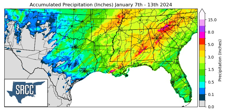
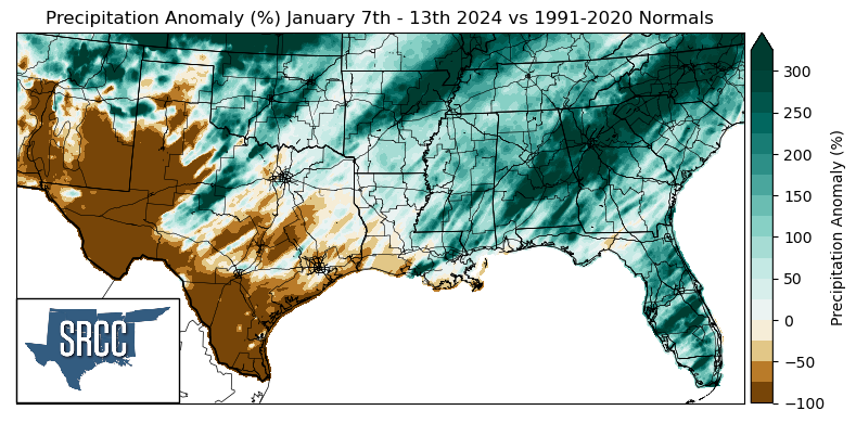
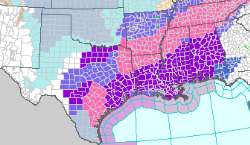
The majority of the precipitation seen across the region last week was due to an advancing low-pressure system across the Gulf states, the cold front bringing rainfall to Southern Oklahoma, North Texas, Louisiana, and Mississippi. The warm front with the system brought rain to Louisiana, Mississippi, Southeast Texas, and Arkansas. Both Arkansas and Oklahoma got another round of precipitation due to Friday's cold front. Where Oklahoma saw this mainly in the form of frozen precipitation. Overall, last week Oklahoma, Arkansas, Tennessee, and Mississippi all saw above-normal precipitation, with Northeast Arkansas seeing three times the normal amount.
Records/Extremes:
- 1/8/2024: Labadieville, LA: EF-0 Tornado
- 1/8/2024: Shipman, MS: EF-1 Tornado
- 1/8/2024: Gonzales, TX: Up to 3 inch hail reported
- 1/9/2024: St. Tammany Parish, LA: 6.86 inches of rain via CoCoRaHS submission
- 1/12/2024: College Station, TX: 47 mph wind gust