03/30/2025 - 04/05/2025
Climate in the News:
Climate.gov recently released a blog, “Winner or bust? Did La Niña shape North American precipitation this winter as expected?” According to the article, La Niña did not dominantly influence rainfall this winter. La Niña is the cool phase of the El Niño southern oscillation, a natural climate pattern that shifts every couple of years and impacts precipitation patterns across the world. Last fall, La Niña was forecasted to emerge and be a weak influence on rainfall from December 2024 to February 2025 (image on the left). Observations from this winter (image on the right) mostly reflect the forecast. In the Southern Region, Texas and Oklahoma received slightly less daily rainfall than the average, while Arkansas, Louisiana, Mississippi, and Tennessee received slightly more.
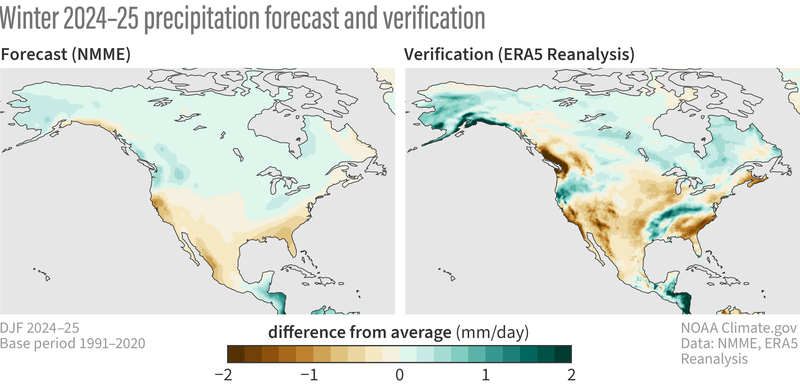
(left) The precipitation forecast for this past winter (Dec-Feb 2024-25) based on the average of all the individual models in the North American Multi-Model Ensemble forecast system produced last fall. (right) The actual precipitation pattern that occurred this past winter from ERA5 Reanalysis, expressed as the difference from the 1991-2020 winter average. NOAA Climate.gov image, based on analysis by Nat Johnson.
Weather Synopsis:
Throughout last week, many surface low pressure systems travelled through the Southern Region. The low-pressure system and stationary front pictured below brought disturbed weather conditions, several days of rainfall, and severe weather hazards.
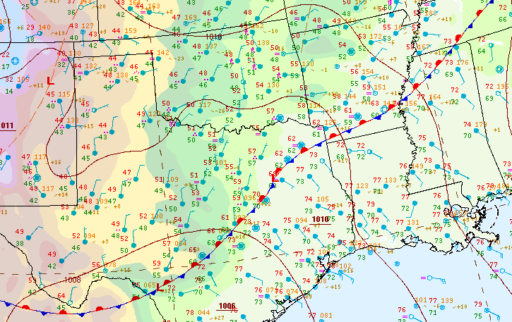
Source: WPC Surface Analysis, 4/4/25 at 7am CDT
Temperature:
Overall, April is when the Region is warming up. However, frequent cold fronts are still common, bringing rain chances and below-normal temperatures for a few days.
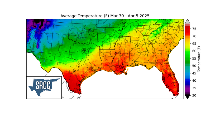
The stationary front previously pictured with the surface low pressure system persisted from Wednesday to Friday. This boundary kept areas north of it colder, and areas south of it warmer. The Oklahoma and Texas Panhandles regularly dropped below 45F while the gulf coast received hotter seasonably average temperatures. Consistent cloud cover along this intersection and small movements of the boundary kept east Texas and Arkansas closer to normal temperatures.
Precipitation:
With the majority of the Region being in a humid subtropical climate, rainfall is common at any point of the year. Frequently, during the spring months, storm systems are also common throughout the south. During April severe storm probabilities are at their highest in Oklahoma and Northeast Texas.
Rainfall was plentiful and frequent last week in the Southern Region. Most of Arkansas and the eastern half of Tennessee received heavy rainfall every day, except for Wednesday. The heaviest rain occurred on Friday, when CoCoRaHS stations in east Texas and Arkansas recorded 6 to 8 inches of rain within a day!