September 2023
Significant Weather Events:


Severe weather is becoming more prevalent again with Fall weather patterns bringing frontal passages through the southern climate region. Most notable was the hailstorm north of Austin, TX. On the night of September 24th, grapefruit-sized hail of 3.75 inches fell in Round Rock, TX. As estimated by Hailtrace, almost 50,000 properties were impacted by hail of 2.50 inches or larger. With this massive hail storm, significant property damage was observed, with damage to roofs, broken windows, and damaged cars being the most common. While weekly fronts have brought thunderstorms and rain to Texas and Oklahoma throughout the month, the rest of the region has been experiencing less precipitation than normal. Developing drought in Louisiana, and Mississippi is starting to reflect in the Mississippi River, where in Vicksburg, MS the river is about 4 feet below the normal water threshold. These low water levels are starting to impact Mississippi farmers, as water levels are too low to allow barges to pass through which in turn interrupts the commerce along it. However, plentiful precipitation has helped the struggling crops in part of Texas. During the middle of the month, AgriLife Today writes, “Over the past week, the Panhandle, South Plains, and parts of Central and East Texas received 2 or more inches of rain to help with crop production and planting for the next season.” In the Southern Plains of Texas, recent rain has helped improve pastures, allowing for some late-season grazing of livestock.
Temperature:
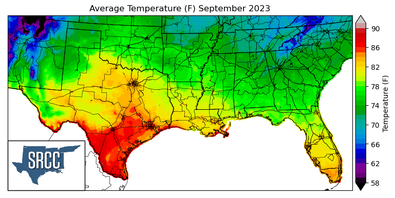
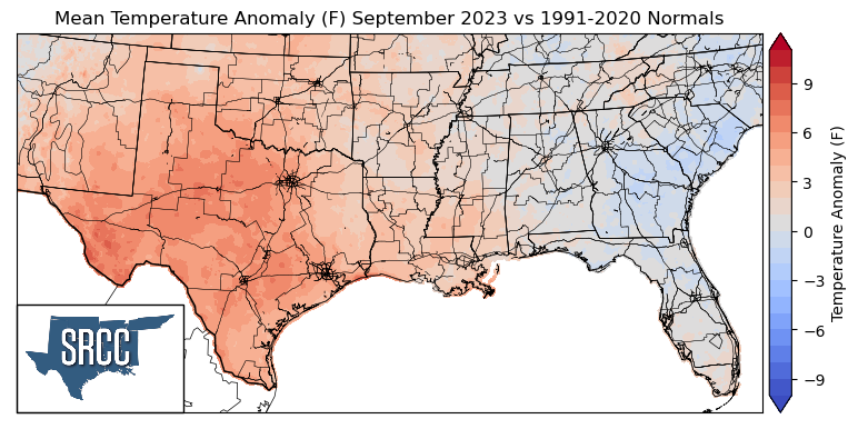
Overall, temperatures were above normal for much of the Southern Region in September, except in Tennessee and Northern Mississippi where temperatures were near normal. The largest departures from normal were observed in far West Texas, averaging 5-7 degrees Fahrenheit above normal, and in Tennessee, where temperatures averaged +1 to -1 degrees Fahrenheit for the month of September. This September felt like a “second summer” for many areas in the climate region, as temperatures were still in the triple digits. Triple-digit temperatures have proven to be very common this year in College Station, TX. On September 21, College Station, TX broke the all-time record from 2011, for most days over 100°F at 70 days and by the end of the month making it to 75 days. The daily average temperatures for the month reached 90 degrees Fahrenheit in South Texas, with the majority of the southern region experiencing daily average temperatures between 87 and 72 degrees. Some of the coldest daily average temperatures were found in the Great Smoky Mountains of Eastern Tennessee, where average temperatures were as low as 66 degrees Fahrenheit.
Precipitation:
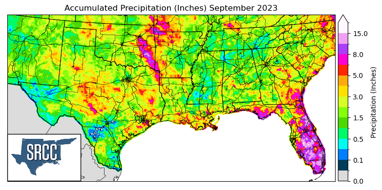
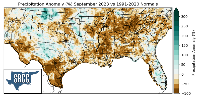
Most areas of the Southern Region during September received less precipitation than normal or near-normal precipitation amounts. The largest negative departures from normal were seen in far West Texas, South Texas, Mississippi, and Tennessee, where precipitation anomalies were -100%. Some of the greatest positive anomalies were observed in the Oklahoma Panhandle, where precipitation was about two times normal. Rainfall was relatively widespread throughout the entirety of the climate region, with accumulated precipitation averaging about 2.0 inches for the month of September across the southern region. However, Eastern Oklahoma saw some substantial amounts of precipitation; where precipitation accumulation totals for the month were about 12.0 inches, due to frequent frontal passages through the area initiating thunderstorms.
Drought:
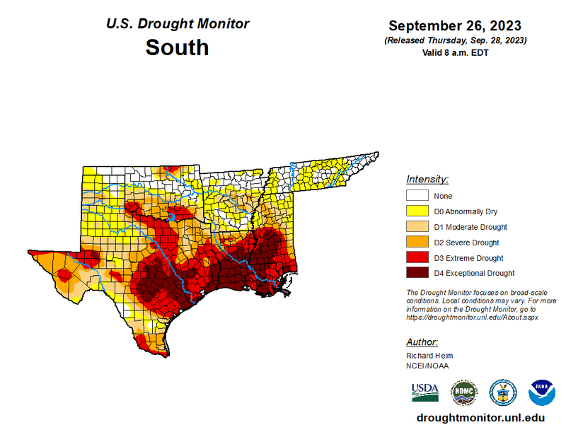
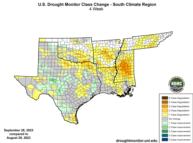
Near weekly frontal passages through Texas and Oklahoma have led to improvements in the two states. Widespread one-class and even some two-class improvements in West-Central Texas can also be attributed to thunderstorm development along the dryline in West Texas. Unfortunately, though, not all areas of the climate region were able to see regular precipitation, leading to developing and worsening drought conditions across the southern region. Widespread degradations were observed in North-Central Texas, Southern Oklahoma, Arkansas, Louisiana, Mississippi, and Tennessee. Last month, drought developed at large in Mississippi. This is best reflected by looking at D2-D4 from the beginning of the month to the end in Mississippi. At the beginning of the month, 32% of the state was experiencing D2-D4 drought conditions, versus 62% at the end of the month, almost double. Drought coverage has also worsened at a regional level, at the beginning of the month, 74% of the region was experiencing varying levels of drought severity. However, as of September 26th, that number has increased to 86%. Not only is the land area of drought increasing, but so has the severity of drought, with 33% of the region currently experiencing D3-D4 drought conditions compared to only 25% at the beginning of the month.
Looking at the U.S. Monthly Drought Outlook for October, the southern climate region can expect drought to persist, remain, yet improve, complete removal, and development. Drought is expected to persist in Far West Texas, along the Texas-Louisiana border, in Louisiana, Central Arkansas, and Mississippi. Areas where drought is expected to remain yet improve are throughout Texas and Southern Oklahoma. Drought removal is likely in the Texas Panhandle, West-Central Texas, and Central Oklahoma. Finally, drought is expected to develop in Tennessee and Northern Mississippi.