October 2023
Significant Weather Events:


The month of October began and ended with large amounts of significant weather. Throughout the middle of the month, things were quite quiet as the majority of the southern region remained dry. But, by the end of the month, dense fog led to a 168-car pileup on Interstate 55 in Louisiana outside of New Orleans. This dense fog was called “superfog” by many media outlets, for several reasons. This is because winds were calm, the atmosphere was fully saturated, and a marsh fire was simultaneously burning close by, leading to fog mixing with the smoke making it denser. This resulted in the death of 7 people and injury of 63 people. Meanwhile in Texas, Oklahoma, and Arkansas, the states experienced multiple days of flash flooding and rainfall. Excessive rainfall totals resulted in the evacuation of 30 people in Warsaw, College Mound, and Kaufman, TX. Flash Flooding also resulted in 2 deaths in Warsaw, TX, where two drivers were swept off the road by moving water.
While some areas received more than enough precipitation this October, some areas remained dry such as Louisiana, Mississippi, and Tennessee. Due to a continued lack of rainfall, in Northern Mississippi and Tennessee, severe though exceptional drought (D2 - D4) conditions have continued to expand in the three states. This has resulted in below-normal water levels in the Mississippi River which has proven to impact corn crops in Mississippi. From BrownfieldAgNews, a Copper County farmer reports that “stalk quality wasn't good and small ears were difficult to shell.” Although, in Texas “recent rainfall is said to bring producers relief and allow winter crops to be planted,” says AgriLife Today. Regan Noland, Ph.D., AgriLife Extension agronomist said, “ This rain is great for our winter crops, It’s too late for the cotton, and a bit late for fall and winter grazing, but will provide producers the soil moisture needed to get winter wheat established and off to a good start.”
Temperature:
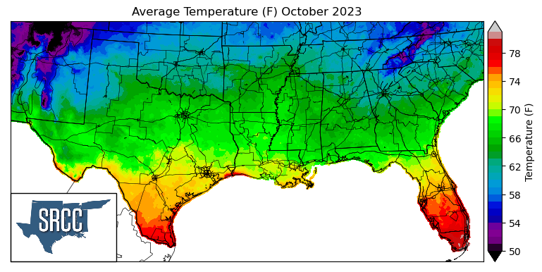
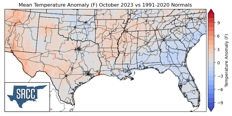
Overall, temperatures were slightly above normal or near normal for much of the Southern Region in October. The largest departures from normal were observed in far West Texas, averaging 4 degrees Fahrenheit above normal for the month of October. The middle of October felt much like summer for many areas in the climate region, as temperatures were still in the 90s. One way that quantifies these summer-like temperatures this October is, on October 20th, College Station, TX set a new daily high temperature of 97 degrees Fahrenheit and also set the record for the number one hottest day this late in the year. Temperature records were continuously broken throughout the third week of the month all across Texas. But, following these record-breaking temperatures was a massive cold front that swept through the region the last weekend of the month. This cold front bringing cold air with it all the way from Canada resulted in temperatures as low as 19 degrees Fahrenheit in Cricket Creek, Arkansas. The daily average temperatures for the month reached 80 degrees Fahrenheit in South Texas, with the majority of the southern region experiencing daily average temperatures between 71 and 60 degrees. Some of the coldest daily average temperatures were found in the Great Smoky Mountains of Eastern Tennessee, where average temperatures were as low as 54 degrees Fahrenheit.
Precipitation:
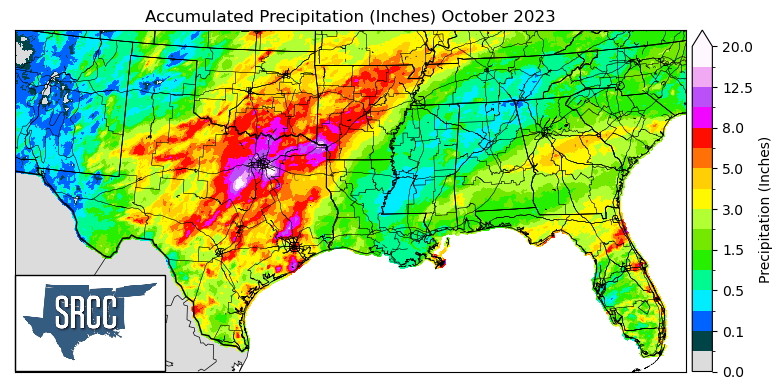
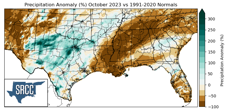
During October the Eastern states of the climate region received below-normal precipitation amounts, whereas Texas, Oklahoma, and Arkansas saw near-normal and above precipitation. The largest negative departures from normal were seen in far West Texas, the Panhandle region, Eastern Louisiana, Mississippi, and Tennessee, where precipitation anomalies were -75%. Some of the greatest positive anomalies were observed in West-Central Texas and Central Texas, where precipitation was about two to three times normal. These substantial amounts of precipitation were one for the books in Dallas/Ft. Worth and Waco, TX, where from October 23rd - 30th, Waco saw eight days of consecutive measurable precipitation, this streak coming in 6th for the longest period. Rainfall was relatively widespread throughout Texas, Arkansas, and Oklahoma, with accumulated precipitation averaging about 6.0 inches for the month of October across the three states. However, the Eastern states of the region seeing below-normal precipitation amounts saw an average precipitation accumulation of 1.5 inches.
Drought:
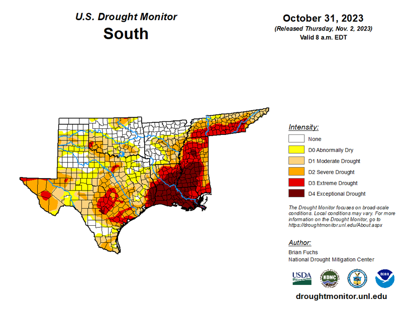
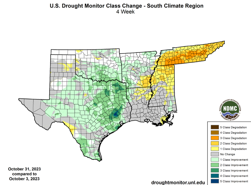
Near weekly frontal passages through Texas, Oklahoma, and Arkansas have led to improvements in the three states. Widespread one-class, two-class, and even up to three-class improvements in Texas and Oklahoma can be attributed to large weekly precipitation accumulations in the last week of the month. For example, Hico, TX received up to 15 inches from October 22nd - 28th, due to a combination of factors but most importantly large amounts of precipitable water in the atmosphere from decaying Post-Tropical Cyclone Norma. Unfortunately, though, not all areas of the climate region were able to see large amounts of precipitation, leading to developing and worsening drought conditions in Southeast Arkansas, Northern Mississippi, and Tennessee. Minimal degradations were observed in Louisiana, where drought was already at its most severe class in most of the state, while the majority of Tennessee saw a three-class degradation for the month of October. Therefore, drought developed at large in Tennessee. This is best reflected by looking at D2-D4 from the beginning of the month to the end in Tennessee. At the beginning of the month, 0% of the state was experiencing D2-D4 drought conditions, versus 70% by the end of the month. But, at a regional level drought coverage decreased due to large-scale improvements in Texas and Oklahoma, at the beginning of the month, 40% of the region was experiencing D1 - D4 drought coverage. However, as of October 31st, that number has decreased to 36.5%. Not only is the land area of drought decreasing, but so has the severity of drought, with 24% of the region currently experiencing D3-D4 drought conditions compared to only 33% at the beginning of the month.
According to the U.S. Monthly Drought Outlook for November, drought is expected to persist for the majority of the region, in West Texas, South Texas, Southwest Oklahoma, Louisiana, Southeast Arkansas, Mississippi, and Tennessee. Areas where drought is expected to remain yet improve are throughout Central Texas, South-Central Oklahoma, and Central Arkansas. Drought removal is likely in Northeast Texas and the Southern Texas Hill Country. Finally, drought is expected to develop further in Central Mississippi and Northeastern Tennessee.