November 2023
Significant Weather Events:


As November draws to a close the southern region is starting to see the beginning of the “cool season”, which means also starting to see the effects of the strong El Niño the Northern Hemisphere is experiencing. Explained in more detail in the 10/8/23 - 10/14/23 Weekly summary, El Niño enhances the subtropical jet stream and subsequently brings higher changes for precipitation during the cool season for the Southern United States. The southern region saw evidence of this on November 20th, when multiple tornadoes were spawned and tracked through Central Louisiana, Central Mississippi, and Southern Mississippi. Most notable was the 23-mile-long track EF-1 in Marksville, LA. Six tornadoes were also reported in Mississippi that same night from EF-0 to EF-1 strength. No injuries or deaths were reported, thankfully, but several properties were damaged. One such was the dwelling in the image above, damaged by a fallen tree, due to the EF-1 Marksville tornado, with up to 100 mph winds. Another notable weather event this past November occurred on the 25th when the northern portions of Texas and Oklahoma saw significant snow for the first time this season. The largest accumulations occurred in Northwest Oklahoma, where Buffalo, OK saw the highest amount of snow in the state: 7.8 inches.
Unfortunately, though, in Mississippi, one storm system was not enough to ameliorate drought significantly as the widespread severe drought remains along the Mississippi River. This problem is not isolated to regional drought conditions as drought conditions in the Midwest have a large effect on the water level due to the tributary rivers they hold. Fortunately, significant precipitation in the Midwest in late October helped raise water levels near Memphis, TN. But, water levels remain below normal near New Orleans, LA, where water levels are so low that it is causing shipping delays. Channels are closing down for dredging because shipping barges are getting stuck in shallow waters, according to the president and CEO of the Waterways Council, Tracy Zea. Meanwhile, in Central Texas, according to AgriLife Today, “sporadic rainfall brought needed relief to some areas and helped with wheat and oats.”
Temperature:
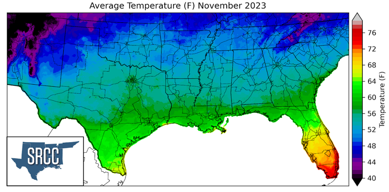
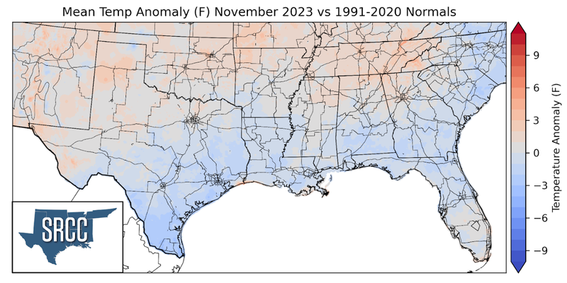
Overall, temperatures were near normal in the southern region for the month of November. Slightly above normal temperatures were experienced in the more northern portions of the region and slightly below normal temperatures in the lesser latitudes of the region, with areas in between experiencing normal monthly average temperatures. The largest departures from normal were observed in Lower Rio Grande Valley, averaging 4 degrees Fahrenheit below normal for November, due to frequent cloud cover limiting daytime heating. The southern region began the month with some record-breaking cold temperatures as a cold front from the end of October left things quite cool and dry. On November 1st across Texas, five stations reported a record-low daily temperature average, and on November 2nd, Natchitoches, LA had a record daily low temperature of 30 degrees Fahrenheit. Following a week of record-breaking cold, the second week of November sure didn't feel like fall with record-breaking high temperatures throughout the region. Some of these records include Harrison, AR setting a record daily high temperature of 84 degrees Fahrenheit or Wichita Falls, TX setting an all-time record high for the month of November at 91 degrees Fahrenheit. Temperature continued to stay above normal for the majority of the region throughout the middle of the month as an upper-level ridge was in place. But, the following week into the end of the month, two strong cold fronts swept through the region keeping temperatures below normal to finish out the month. The result was daily average temperatures for the southern region ranging between 62 and 48 degrees in most places. Some of the coldest daily average temperatures were found in the Great Smoky Mountains of Eastern Tennessee, where average temperatures were as low as 43 degrees Fahrenheit.
Precipitation:
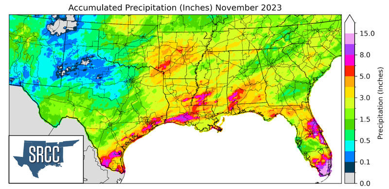
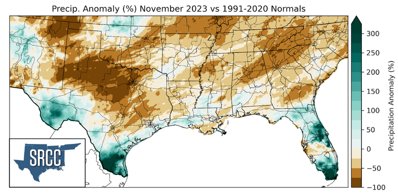
During November the majority of the climate region received below-normal precipitation amounts, but on the other hand, Far West Texas and the Rio Grande Valley were able to see above-normal precipitation accumulations. The largest negative departures from normal were seen in Northwest Texas and North-Central Texas, where precipitation anomalies were -100%. The greatest positive anomalies were observed in portions of the Lower Rio Grande Valley, where precipitation accumulations were about two to three times normal. This is mostly thanks to a coastal low beginning/mid-month that brought several days of rainfall to the region. Areas in Starr County, TX saw monthly accumulations as high as 10 inches. Rainfall was relatively widespread throughout Arkansas, Louisiana, and Mississippi, with accumulated precipitation averaging about 5.5 inches for the month of November across the three states. However, North Texas and areas of Oklahoma seeing below-normal precipitation amounts saw an average precipitation accumulation of one inch, with some areas in the Panhandle not receiving any rainfall this past month.
Drought:
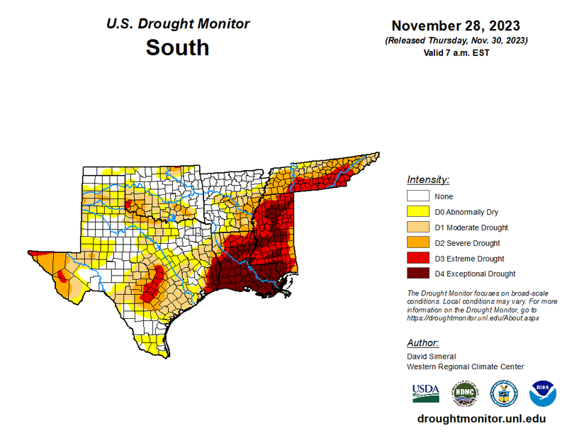
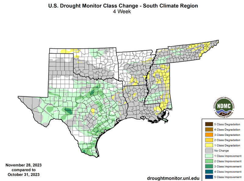
In the middle of November, the majority of Texas experienced two weeks of consistent rainfall, with moderate rainfall accumulations. Therefore, widespread one-class and two-class improvements were seen in North-Central Texas, Central Texas, West Texas, and South Texas. Some three-class improvements were also seen in Schleicher, Sutton, Hood, and Starr Counties. Drought improvements were also seen in North-Central Oklahoma, Western Tennessee, and Southern Mississippi. Unfortunately, though, not all areas of the climate region were able to see substantial amounts of precipitation, leading to developing and worsening drought conditions in the Oklahoma Panhandle, Northern Mississippi, and Eastern Tennessee. Minimal degradations were observed in Louisiana and Southern Arkansas. Thankfully, South-Central Mississippi was able to experience some improvement this month, occurring due to a severe storm system that ripped through the southern portion of the region on November 20th. Although, for drought removal in Southern Mississippi, about 18 inches of rain is still required. Large-scale improvements in Texas can be seen by looking at Texas county burn bans. Eight weeks ago 199 counties were under a burn ban, and as of November 30th, that number had decreased to 67. At a regional level drought improvements and degradation have almost canceled each other out. This can be seen by looking at the cumulative percent area of the southern region experiencing D1-D4 drought coverage. At the end of October, 36.5% of the region was experiencing D1-D4 drought conditions, versus 36% by the end of the month, so drought coverage has decreased just slightly. The case remains the same for drought severity as well, at the end of October 7.9% of the region was experiencing D3-D4 drought conditions, experiencing a slight decrease to 7.8% by the end of the month.
According to the U.S. Monthly Drought Outlook for December, drought is expected to persist for the majority of the region, in West Texas, Central Texas, and Southwest Oklahoma. Areas where drought is expected to remain yet improve are throughout East Texas, Louisiana, Southeast Arkansas, Mississippi, and Tennessee. Drought removal is likely in the Lower Brazos Valley and Houston area.