March 2024
Significant Weather Events:
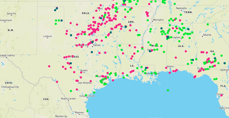
Along with the start of March was the start of meteorological spring. Spring is when the Southern Region sees the highest frequency of severe weather. This March, across the Region there were 15 reported tornadoes, about 100 reports of wind damage, and over 150 hail reports. Mid-month is when severe weather ramped up, with widespread severe weather occurring on March 14th. Weak tornadoes, hail, and strong winds were seen from Central Oklahoma as far as Mississippi as this storm system advanced. Then on March 24th, storm activity on the dryline (moisture boundary) in Northwest Texas resulted in several weak tornadoes from EF-0 to EF-1, with no deaths or injuries reported.
Discussed in last month's summary was the Smokehouse Creek fire, which spread to 1,058,482 acres. The fire was fully contained by March 16th. The damage from this was substantial to the agricultural sector. In the Crop Progress report the USDA states, “The wildfires in the Northern High Plains caused catastrophic damage to the area with heavy livestock losses reported and over 1 million acres of pastures and rangeland burned.” Red flag warnings continued into March in the Texas Panhandle. Thankfully, despite favorable conditions on March 23rd and 24th no fires ignited.
Rainfall differed vastly across the different states in the Southern Region this March. According to the USDA, rainfall totals in Oklahoma averaged 1.73 inches. As of March 26th 34% of the state is seeing abnormally dry conditions to severe drought conditions, resulting in topsoil and subsoil moisture to be poor. Conditions in Mississippi were much more favorable, where 76% of topsoil moisture supplies were 76% adequate. Warm temperatures to start the month also led to improving pasture conditions.
Temperature:
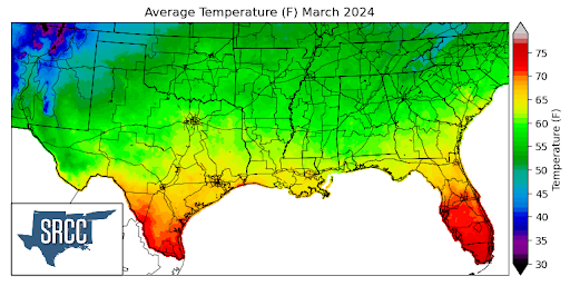
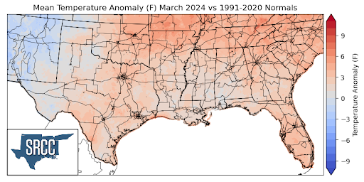
Temperatures were just slightly above normal for the majority of the Southern Region for the month of March, although monthly average temperatures were near normal in West Texas. The largest departure from normal was observed north of Knoxville, Tennessee, averaging about 5 to 6 degrees Fahrenheit above normal. The Southern Region started out the month quite warm as an upper-level ridge dominated the weather pattern, resulting in temperatures for the first week being as much as 10 degrees above normal across all of Arkansas, Tennessee, Louisiana, and Mississippi. Despite several cold fronts making their way through the region, temperatures remained warmer than normal until the week of the 17th. A strong cold front brought relief to the heat as it moved south through the region on March 17th. This left behind a cool and dry air mass that stayed in place for several days. In the last week of March two additional cold fronts followed, keeping temperatures below normal to finish out the month. This all resulted in March’s average temperatures for the Southern Region ranging between 68 and 52 degrees in most places. Some of the warmest daily average temperatures for March were found in the Lower Rio Grande Valley, where monthly average temperatures were as high as 72 degrees Fahrenheit.
Precipitation:
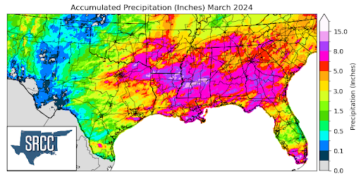
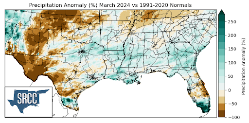
Near-normal precipitation totals were seen in much of the Southern Region, with the exclusion of West Texas, Southwest Texas, and most of Oklahoma where these areas saw below normal monthly precipitation totals. Multiple storm systems started in Northeast Texas and Eastern Oklahoma along surface boundaries. These storms then tracked into the Eastern states of the Region (Arkansas, Louisiana, Mississippi, and Tennessee) where they brought severe weather and heavy rains. In particular, heavy rainfall on 14th and the 15th in Arkansas resulted in flash flooding. Within 24 hours 6 inches of rain fell in southwestern Arkansas. Another system that was responsible for much of the rainfall last month was a stationary front that stalled along the Gulf Coast on the 17th. Finally in the last week of March, two low-pressure systems moved through the Region resulting in widespread precipitation from East Texas to Western Tennessee. Monthly accumulations in Arkansas, Louisiana, and Mississippi averaged about 8 inches, with the areas along I-20 in Mississippi seeing as much as 15 inches this March! Overall, precipitation this month followed an anticipated pattern, with the highest accumulations concentrated among the Gulf states and the ArkLaTx area as El Niño conditions stuck around.
Drought:
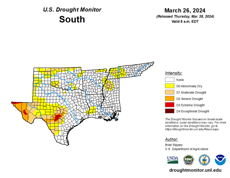
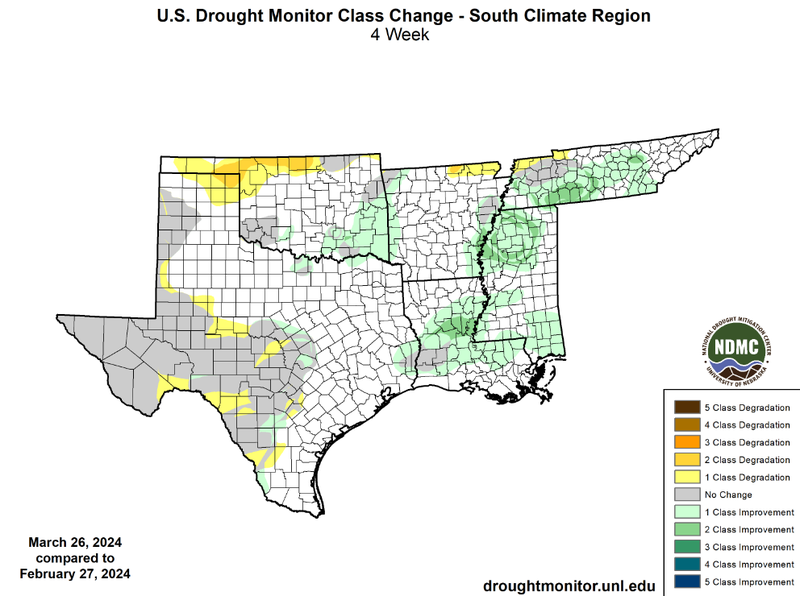
In March plentiful moisture and other ingredients for storms were common in the Lower Mississippi Valley, resulting in semi-frequent rainfall. Temperatures started out the month quite warm and then favored colder than normal averages as the month drew to a close. Overall, large monthly precipitation accumulations in Louisiana, Mississippi, Tennessee, and Southeast Oklahoma led to widespread drought improvements. While improvements were less significant than the months prior, Central Louisiana, Northern Mississippi, and Southern Tennessee did manage to see some two-class improvements. Additionally, some small one-class improvements were seen in South and Central Texas. Unfortunately though, a lack of significant rainfall and warm temperatures to start out the month resulted in flash drought conditions in Northern Oklahoma. In the beginning of March many areas in Northern Oklahoma had gone 30 to upwards of 55 days without a significant amount of rainfall. The continued lack of sizable rainfall and dry soil conditions resulted in two-class degradations in some areas, introducing moderate drought (D1) to the area. Some one-class degradations also occurred across the region, in West Texas, Southwest Texas, and along the northern borders of Arkansas and Tennessee. At a regional level, though, drought conditions improved slightly. This can be seen by looking at the cumulative percent area of the southern region experiencing D1-D4 drought coverage. At the end of February, 17% of the region was experiencing D1-D4 drought conditions, versus 15% by the end of March. Drought severity remained the same with only one percent of the region experiencing exceptional drought (D3-D4).
According to the U.S. Monthly Drought Outlook for this Spring, drought is expected to remain yet improve in Northwestern Mississippi.. Drought is expected to persist in Far West Texas and in areas of South-Central Texas. Drought development is likely in West Texas and North Texas. Finally, drought removal is likely in isolated areas of Central Louisiana and Western Tennessee.