June 2023
Significant Weather Events:
June was a busy month for severe weather across the region, with a persistent high-pressure system dominating the weather pattern. Despite this, small-scale lifting mechanisms provided favorable conditions for storms to develop rapidly and become severe. Abundant moisture and intense heat further fueled the intensity of these thunderstorms. One notable event was the Matador, Texas Tornado, on June 22nd, which caused significant damage at an EF3 intensity. The tornado followed Texas Highway 70 through the western part of town, resulting in four fatalities, 15 injuries, and extensive property damage. Another destructive storm occurred in Perryton, Texas, on June 15th, where an EF3 tornado claimed the lives of three individuals and left over 100 injured.
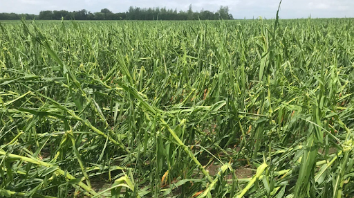
Large hail was a common occurrence during the thunderstorms in June, owing to the high levels of surface moisture and temperature. On June 14th, a hailstone measuring 5 inches was reported in Brooksville, Mississippi, while Wheeler County, Texas, witnessed a hailstone measuring 5.5 inches. These frequent hail storms caused damage to both property and crops.
Corn crops, in particular, suffered significant damage from hail and/or wind during their later stages of development. Other crops such as cotton and soybeans were also affected, but due to their stage of maturity, they should be able to recover from the damage or be replanted.

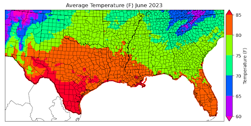
Temperature:
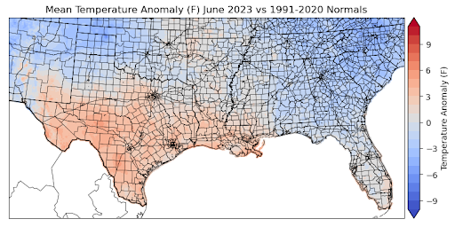
Overall, temperatures were above or near normal for much of the Southern Region in June. The largest departures from normal were observed in West-central Texas, averaging 4-6 degrees Fahrenheit above normal, and in the Texas/Oklahoma Panhandles, where temperatures averaged 3-5 degrees below normal for the month of June. Looking back, much of Texas and Louisiana experienced many days of excessive heat warnings and heat advisories. The remarkable heat of this June can be best exemplified by looking at the record high temperatures that persisted for ten consecutive days in Del Rio, Texas. During this time period from June 17th to the 27th temperatures reached as high as 115 degrees Fahrenheit. The daily average temperatures for the month exceeded 85 degrees Fahrenheit in South Texas, with the majority of the southern region experiencing daily average temperatures between 75 and 85 degrees. Some of the coldest daily average temperatures were found in the Great Smoky Mountains of Eastern Tennessee, where average temperatures reached 65 degrees Fahrenheit.
Precipitation:
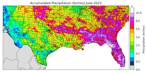
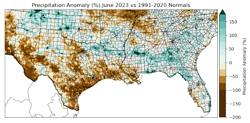
Looking across the southern region for the month of June, most areas received less precipitation than normal or normal precipitation amounts. The largest departures from normal were seen in West and South Texas, where precipitation anomalies were 100 percent below normal. Some of the greatest positive anomalies were observed in localized regions in Western Oklahoma and Central Mississippi, where precipitation anomalies were 200 percent above normal. Rainfall was relatively widespread throughout the region, with accumulated precipitation averaging about 2.0 inches for the month of June across the entire region. However, several areas received much more than this, such as Leake County in Central Mississippi, where precipitation accumulation for the month reached as much as 12.0 inches. Many late-season severe storm systems dumped substantial amounts of rain on areas in Arkansas and Mississippi. In Jackson County, Mississippi, a 24-hour rainfall accumulation of 5.63 inches was recorded via CoCoRaHS on June 23rd.
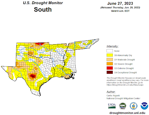
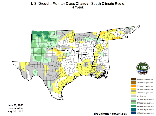
Drought:
While drought intensity has improved for the Panhandle region and Western Oklahoma, overall dry conditions have led to drought becoming more widespread throughout much of the Southern Region in the month of June. At the beginning of the month, 48% of the region was experiencing varying levels of drought severity. However, as of June 27th, that number has increased to 63%. Although the severity of drought has decreased, with only 20% of the region currently experiencing D1-D4 drought conditions compared to 24% at the beginning of the month, drought has expanded in terms of coverage. The Panhandle region has seen a significant improvement in drought conditions, due to many thunderstorms this June. This has resulted in a three-class improvement in drought conditions for that area. Conversely, dry conditions in North Texas and Tennessee have led to a two-class degradation in those regions. As hot and dry conditions are expected to continue throughout July, the Climate Prediction Center has identified areas of South Texas and Louisiana as being at a "rapid onset drought risk".