January 2024
Significant Weather Events:

January was quite average in terms of severe weather. Most storm reports that came out of the month occurred on January 8th and 9th due to a low-pressure system and its associated cold and warm fronts acting as a trigger mechanism for storms. On the 8th two EF-0 tornadoes occurred, one in Coldspring, TX and the other in Labadieville, LA, no injuries or deaths were reported. Throughout the month there were 33 hail reports, the biggest of which was in Newton, TX where up to a four-inch hailstone fell. Finally, January was a windy month with non-thunderstorm gusts reaching 50 mph in North-Central Texas.
When looking back at the past month we can't forget to mention the arctic blast that brought subfreezing temperatures and frozen precipitation across the southern region. Wind chills made it well below zero in much of the Southern Region. Nearly the entire region saw some type of frozen precipitation with this event, leading to school closures and travel hazards. On the morning of January 15th, the Nashville Police reported over 20 crashes. Texas residents were advised to conserve power as the state’s electric grid was close to reaching capacity. This may have caused your plants to freeze but winter crops are in good condition.
According to the Oklahoma Farm Report, 63% of the winter wheat crop is reported to be in good condition, this is 10% from the end of 2023. Pasture and range ratings are also in the good to excellent range. The case is much the same for Texas, Larry Stein of Texas A&M AgriLife Extension states even the cold spell in mid-January did not negatively impact wheat crops. Looking forward, Stein says that Texas farmers are optimistic they will receive the necessary rainfall into the spring.
Temperature:
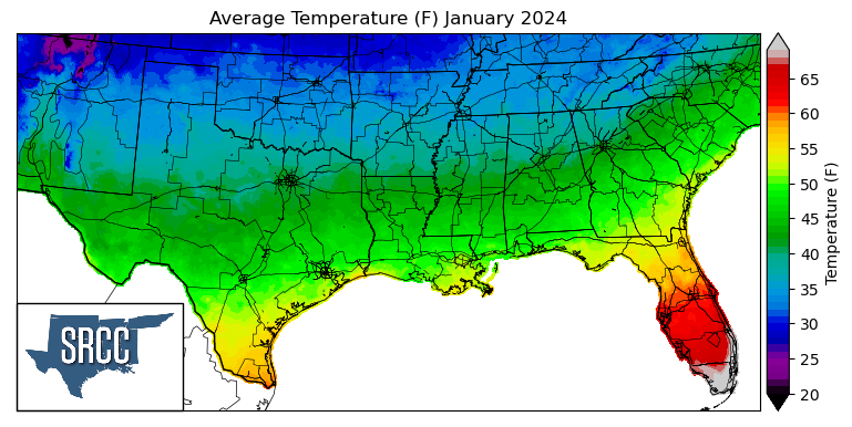
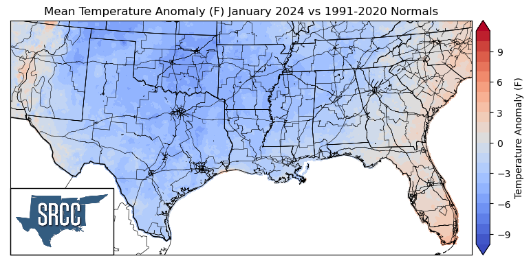
Temperatures were below normal for almost the entirety of the southern region for the month of January. Overall, North-Central Texas and Oklahoma saw the largest departures from normal, averaging about -5 to -6 degrees Fahrenheit. The Southern Region started out the year with a strong cold front making its way through the region, leaving behind below-normal temperatures for much of the region. Then temperatures sat around normal for a few days until several cold fronts passed through the region from the 8th to the 13th, not allowing things to warm up very much during the week. This last cold front brought with it an arctic air mass from Canada and significantly cooled down the region. Mid-month weekly temperature averages were 15 to 20 degrees Fahrenheit below normal, and new record low temperatures were set left and right. Some of the daily low record temperatures from the 16th include -2°F, in Tulsa, OK, -10°F in Fayetteville, AR, and 17°F in College Station, TX. Thankfully, at the end of the month, things started to warm up as we saw upper-level troughing bringing spring-like temperatures. This all resulted in daily average temperatures for the southern region of the month ranging between 50 and 35 degrees in most places. Some of the coldest daily average temperatures for January were found in the Oklahoma Panhandle, where monthly average temperatures were as low as 30 degrees Fahrenheit.
Precipitation:
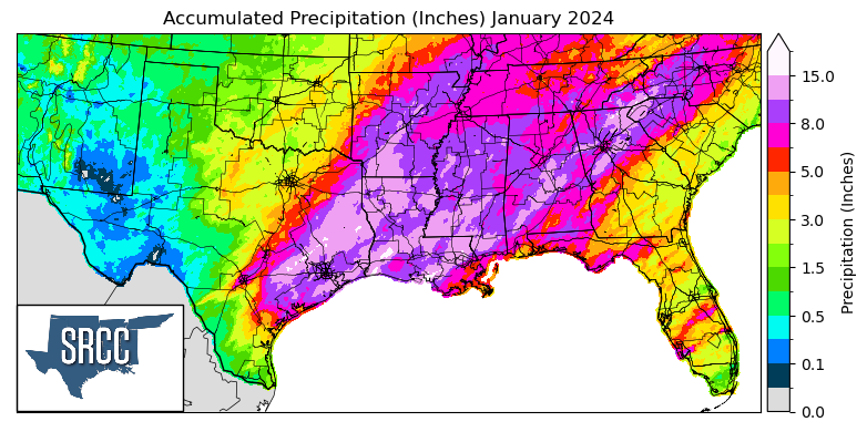
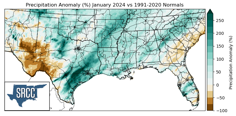
Much of the southern region saw above-normal precipitation totals for the month of January with the exclusion of West Texas, consistent with the expected effect of a strong El Niño for the Southeastern United States. Several storm systems made their way through the gulf states this month, most notably at the end of the month a warm front that stalled as it made it inland and was responsible for about ⅘ of the precipitation seen last month in Central Texas. The nearly five and a half inches of rain falling in San Antonio from January 21st to January 25th made 2024 the second wettest January on record for the city. Prolonged rainfall resulted in saturated soils which led to intense flash flooding in New Orleans, leaving many roads impassable and resulting in several high water rescues. Not only were rainfall records being set, but mid-month in Tennessee an entire winter's worth of snow was falling on Nashville. On January 15th, 6.3 inches of snow fell, breaking the daily snowfall record, and as that snow started melting it also posed a flooding risk. While some areas received much more rainfall than others, precipitation was still widespread this month, as anticipated during the cool season of a strong El Niño.
Drought:
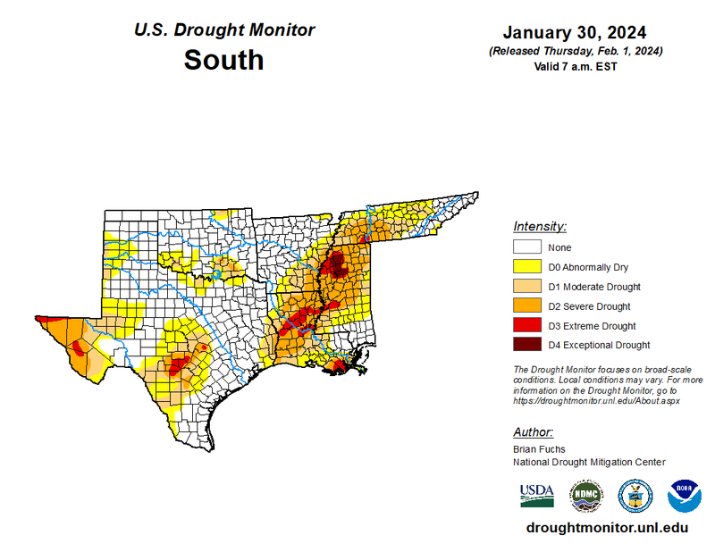
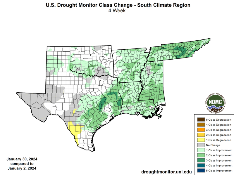
In January the majority of precipitation accumulations occurred at either the beginning or end of the month, when temperatures were warm enough to support thunderstorm development. Following the arctic blast of cold air in the middle of the month, temperatures were quite frigid and only small accumulations of frozen precipitation were seen, with the exception of Arkansas and Tennessee, where snowfall depths were notable. Overall, large monthly precipitation accumulations across the region led to widespread drought improvements. Substantial amounts of snowfall in Nashville, TN led to a three-class improvement, a large two-class improvement, and a statewide one-class improvement. More frozen precipitation led to improving drought in Arkansas as well with more two and one-class improvements. More one-class improvements were seen in Louisiana, the Texas Panhandle, Southern Oklahoma, and Central Texas. Finally, Mississippi, which started off the month with 62% of the state in extreme to exceptional drought (D3 - D4) was able to see widespread two-class improvements leading to now only 13% of the state experiencing those drought conditions. Unfortunately, extreme drought (D3) still exists in Louisiana but its percentage is also significantly down and so is the amount of rain required to remove drought in Central Louisiana, which is down by 4 inches from last month to now 14 and a half inches. At a regional level, drought conditions have improved vastly. This can be seen by looking at the cumulative percent area of the southern region experiencing D1-D4 drought coverage. At the beginning of January, 52% of the region was experiencing D1-D4 drought conditions, versus 30% by the end of the month. Drought severity also decreased significantly from 5% of the region experiencing exceptional drought (D4) at the beginning of January to less than one percent by the end of January.
According to the U.S. Monthly Drought Outlook for February, drought is expected to remain yet improve in much of the region, in Central Texas, Louisiana, Southeast Arkansas, Mississippi, and Western Tennessee. Drought is expected to persist in Far West Texas. Finally, drought removal is likely in areas of Southern Oklahoma, along I-10 in Southern Louisiana, Southern Mississippi, and Northern Tennessee.