February 2024
Significant Weather Events:
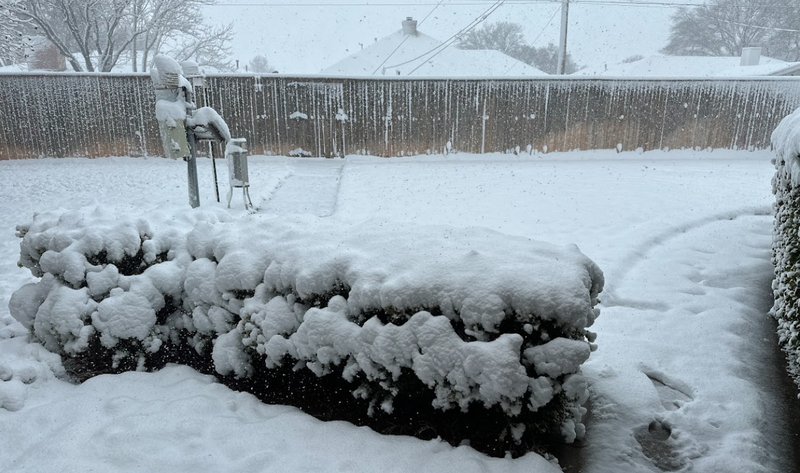
North Texas and the Texas Panhandle saw a wide range of significant weather this month, from snowstorms to wildfires, but first, the region started out the month with a storm system that brought severe weather to North Texas. A typical spring-like severe weather setup occurred on February 2nd, leading to large hail and even an EF-2 tornado near Sagerton, TX. Minimal damage was reported along with no injuries. By mid-month, the same low-pressure system that brought severe storms to Texas, Arkansas, Louisiana, and Mississippi on the 11th and 12th, brought a snowstorm to the Texas Panhandle and Oklahoma. Snow fell on Superbowl Sunday throughout most of the south plains. This caused travel hazards with slush and snow-covered roadways, delaying school starts the following day. The highest snowfall totals from this were seen in Plainview, TX where over a foot of snow fell. North of Lawton, OK, snowfall totals were also quite considerable with much of the area seeing 4 inches to upwards of a foot. Sunshine and warming temperatures throughout the beginning of the week melted the snow quite quickly.
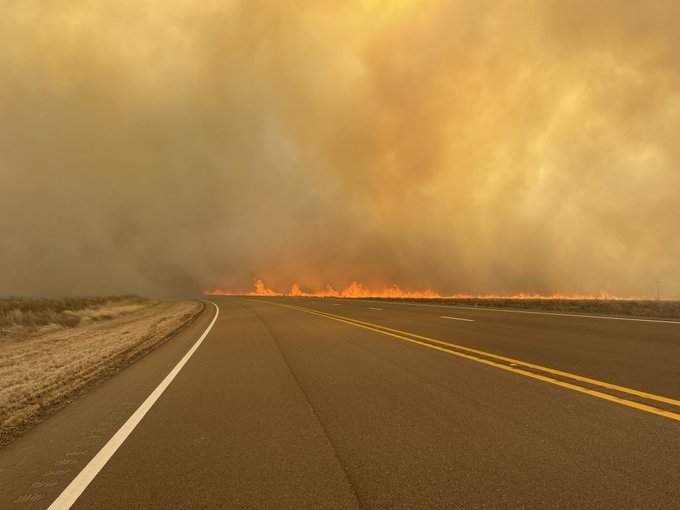
By the end of February, temperatures had warmed up quite considerably across the region, and in West Texas specifically, temperatures reached 90°F in Lubbock, TX on February 26th. Meanwhile, high winds and low relative humidity values resulted in red flag warnings from the Texas Panhandle to northern Arkansas. Due to these favorable conditions, several large wildfires ignited in the Panhandle on the 26th. Most notable is the Smokehouse Creek Fire in Hutchinson County which has spread to an estimated 1,075,000 acres, making it the largest wildfire in Texas history. Not only did plentiful fuel and the right conditions help this fire get so large but a cold front that moved through the area on the 27th shifted the wind direction leading them to spread even more. As of March 1st, the fire remains 5% contained. So far these fires have managed to burn down hundreds of homes in Fritch, TX, according to KCBD news and at this time 2 deaths have been reported. Thankfully some frozen precipitation fell on the 29th which helped to prevent the further spread. Unfortunately though, as we move into the weekend winds are expected to pick back up, resulting in a Fire Weather Watch for the Panhandle and Western Oklahoma.
Spring-like temperatures and frequent rainfall throughout much of the month have favored the agricultural sector. The USDA states that in Tennessee, “Most producers report that seeded winter wheat remains in good shape thus far. Pastures are slowly recovering from the fall drought and January deep freeze with cool season grasses starting to come in.” In Texas, according to AgriLife Today, cool-season crops, like the cabbage growing in the Rio Grande Valley area fields, are doing well thanks to fall rains and reasonably mild temperatures.
Temperature:
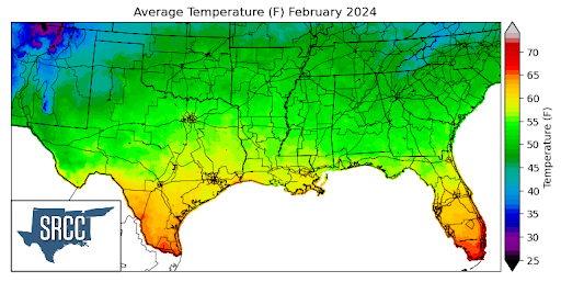
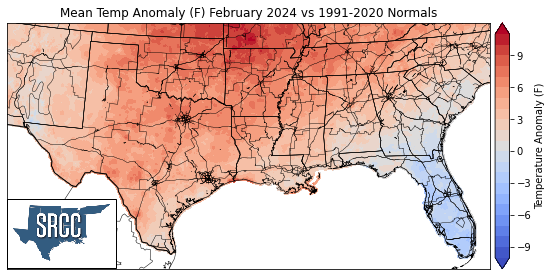
Temperatures were above normal for almost the entirety of the southern region for the month of February. Overall, Northern Arkansas saw the largest departures from normal, averaging about 6 to 7 degrees Fahrenheit above normal. The southern region started out the month with spring-like temperatures as an upper-level ridge dominated the weather pattern, resulting in temperatures for the first week being as much as 15 degrees above normal in Oklahoma. Warmer temperatures remained until a strong cold front passed through the region mid-month. However, by the end of the month more upper-level ridging warmed things back up again. Temperatures were as much as 25 degrees above normal on the 26th in Texas and Oklahoma. Multiple stations across the region set record-high daily temperatures from Texas to Mississippi. Temperatures felt like summer for those in Texas as on the 27th, Killeen, TX hit a record high of 100°F, which is also the first station to hit triple digits this year. To finish out the month a strong cold front passed through the region from the 27th into the 28th bringing temperatures down, and back to what we would expect out of February. This all resulted in daily average temperatures for the southern region of the month ranging between 59 and 47 degrees in most places. Some of the warmest daily average temperatures for February were found in the Lower Rio Grande Valley, where monthly average temperatures were as high as 65 degrees Fahrenheit.
Precipitation:
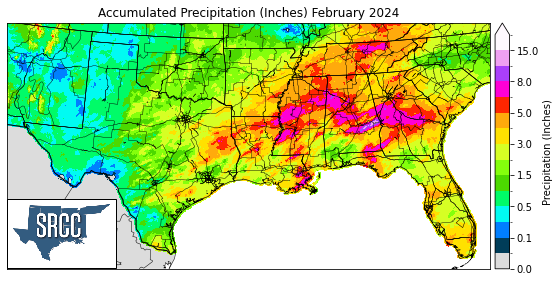
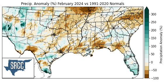
Much of the southern region either saw near-normal or below-normal precipitation totals for the month of February. West Texas was finally able to receive some precipitation on the 29th after much of the area did not receive as much as a trace up until then. Several storm systems made their way through the Gulf states this month. A stationary front draped itself across the region on the 10th, firing off several thunderstorms, some severe. This frontal boundary was responsible for a large portion of the precipitation observed across the southern region last month. Regular sea-breeze-initiated thunderstorms led to wetter than normal conditions for the Lower Rio Grande Valley in Texas. Most of this rain fell mid-month where from the 11th to the 17th about 5 inches of rain fell in McAllen, TX. Overall, precipitation this month followed an anticipated pattern, with the highest accumulations concentrated among the Gulf states as El Niño conditions stick around.
Drought:
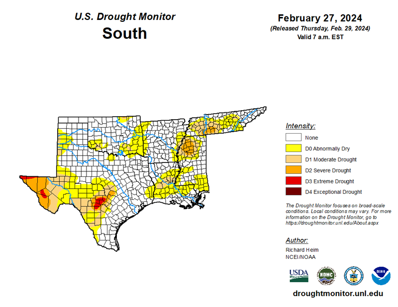
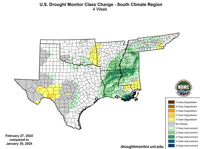
In February weekly frontal passages brought consistent rainfall to the eastern portion of the region. Temperatures were quite warm for February and these spring-like temperatures were felt throughout the month. Overall, large monthly precipitation accumulations in Louisiana, Mississippi, Tennessee, and Southeast Arkansas led to widespread drought improvements. Several squall lines tracked through Louisiana and into Mississippi resulting in widespread two and even three-class improvements in the two states. Additionally, four-class improvements near New Orleans alleviated drought conditions along the Gulf Coast in Louisiana. At a state level, Louisiana, which started off the month with 71% of the state experiencing some level of drought conditions, was able to see vast improvements leading to now only 9% of the state still experiencing drought. Extreme drought (D3) in the southern region can only be found in Texas, in both Central and far West. Minor improvements were also seen in Southern Oklahoma and areas of Central Texas. Some one-class degradations also occurred across the region, in Southern Mississippi, along the Oklahoma-Arkansas border, and in West Texas. At a regional level, though, drought conditions continued to improve. This can be seen by looking at the cumulative percent area of the southern region experiencing D1-D4 drought coverage. At the end of January, 30% of the region was experiencing D1-D4 drought conditions, versus 17% by the end of February. Drought severity also decreased significantly from 3.6% of the region experiencing extreme and exceptional drought (D3-D4) at the end of January to only 1 percent by the end of February.
According to the U.S. Monthly Drought Outlook for March, drought is expected to remain yet improve in Northwestern Mississippi and areas of Southern Tennessee. Drought is expected to persist in Far West Texas and in South-Central Texas. Drought development is likely in West Texas. Finally, drought removal is likely in areas of Central Louisiana and Western Tennessee.