April 2025
Significant Weather Events:
April began with a historic severe weather outbreak in the Southern Region. The National Weather Center’s Storm Prediction Center issued a level 5/5 high risk for severe weather including much of eastern Arkansas and western Tennessee for April 2nd. Combined with this a level 5/5 high risk for excessive rainfall was issued from the Weather Prediction Center, for a similar area. A generational flooding outbreak occurred over the first week of April. Many roadways were completely flooded and several high water rescues occurred. Many rainfall records were shattered and up to 13 inches of rain fell in some areas of Central Arkansas and Western Tennessee. This catastrophic flooding resulted in extreme crop damage in Arkansas. The University of Arkansas Division of Agriculture estimated crop damage from this event to exceed $78 million.
Flooding was not the only devastating hazard with this storm system, a historic tornado outbreak also occurred. One hundred and fifty-six tornadoes were confirmed from April 1st through April 7th, of which six were EF-3’s. Four of these EF-3 tornadoes occurred in the Memphis, Tennessee National Weather Service County Warning area. These four tornadoes resulted in 7 fatalities and 26 injuries in Eastern Arkansas, Northwest Mississippi, and West Tennessee. The timing of these tornadoes is what made them so deadly, as they occurred between midnight and 2 am.
Unfortunately, another nocturnal tornado threat would threaten the mid-south, this time in North-Central Texas. On Saturday, April 19th, severe thunderstorms formed in West Texas dropping large hail, with diameters over two inches. As the day progressed, storms moved into the Dallas-Ft. Worth Metropolitan area after dark. These storms resulted in three EF-0, four-EF-1, and one EF-2 tornado. Thankfully, no injuries or fatalities were reported.
In the last week of April severe storm activity showed no signs of slowing down. A tight dryline (moisture gradient) set up in West Texas, allowing several days of back-to-back severe thunderstorms to develop, yielding all hazards including tornadoes, severe wind, and damaging hail. Baseball sized hail and damaging tornados were not uncommon.
Temperature:

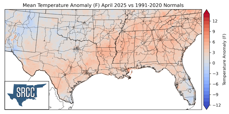
The monthly average temperature in April was near-normal in the Southern Region, although slightly above normal temperatures were observed in the eastern portion of the Region. This near-normal temperature signal was characterized by several strong cold fronts which swept through the Southern Region. Monthly average temperatures ranged from 75 degrees in Deep South Texas to around 60 degrees in the Oklahoma Panhandle and the Great Smoky Mountains.
Precipitation:
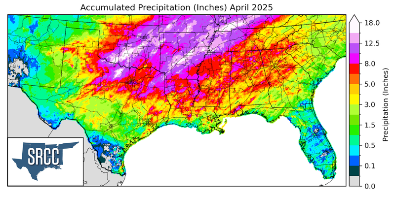
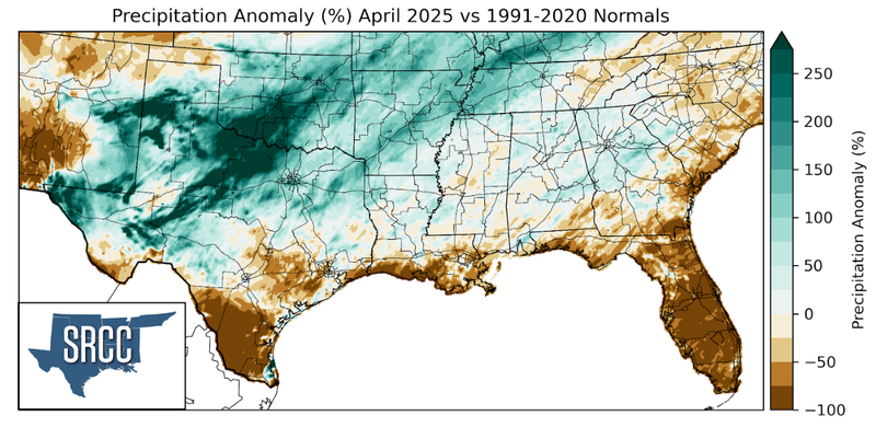
Precipitation departures from normal varied spatially across the Southern Region. In the southern reaches and along the coast, precipitation totals were below normal. Areas that saw greater than normal precipitation totals were concentrated in the northern half of the Region. Notably, the Rolling Plains of Texas, areas of the Texas Panhandle, and parts of Far West Texas saw monthly precipitation totals three times normal. Much of this rainfall came from thunderstorms that initiated along the dryline in West Texas, before growing upscale and moving east. As previously discussed, generational flooding occurred at the beginning of April, followed by regular rain events each week throughout the month. Overall, the Southern Region saw plentiful rainfall this April. The highest totals were concentrated in the northern half of the Region, where a monthly total of eight inches was not uncommon.
Drought:
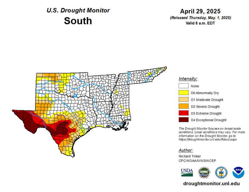
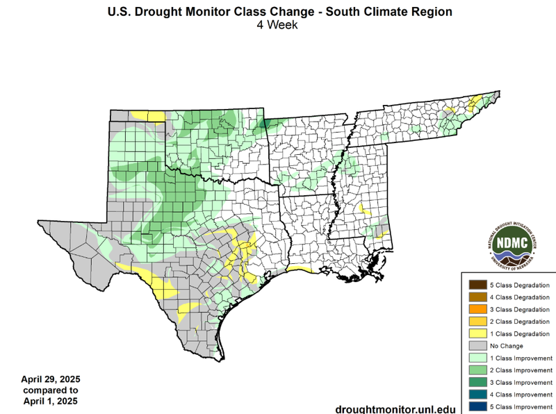
Spring showers were in full swing this April. Rainfall was widespread throughout the Southern Region, with the greatest totals concentrated in the northern half of the Region. It was a very rainy month, and thus, less-than-normal precipitation totals were uncommon. Although below normal precipitation totals were found near the Gulf Coast and in the Oklahoma Panhandle. As a result, one-class degradations were observed in the Oklahoma Panhandle, Southwest Texas, and Southeast Texas. These degradations resulted in the expansion of severe to exceptional drought (D2 - D4). However, this was not the main trend for the month. Overall, drought conditions vastly improved across the Southern Region. Widespread one and two-class improvements were observed in West Texas, West-Central Texas, and Oklahoma. Some additional one-class improvements were observed in South Arkansas and Eastern Tennessee. These improvements resulted in the amelioration of drought in the associated areas. Due to these improvements, drought conditions contracted at a regional level in April. From the beginning to the end of April, the percentage of the Southern Region experiencing abnormally dry (D0) to exceptional drought (D4) dropped 20%. At a regional level, drought severity (D3- D4) also decreased by nearly 1.5% throughout April.
According to the U.S. Monthly Drought Outlook for this May, drought is expected to remain yet improve throughout much of Texas. Drought is expected to persist in Far West Texas. Finally, drought removal is likely in areas of Oklahoma.