09/07/2025 - 09/13/2025
Climate in the News:
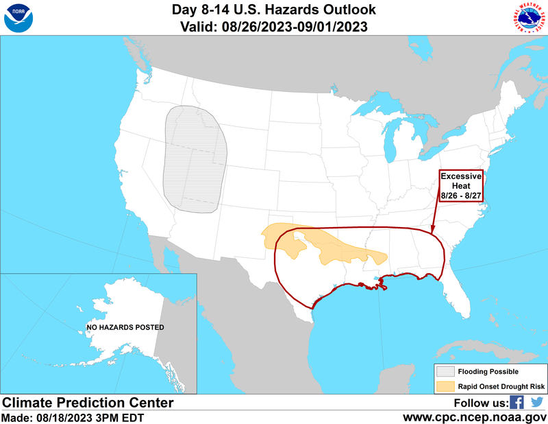
The Climate Prediction Center’s Hazards Outlook for next week (September 22nd – 28th) highlights drought in Mississippi and East Central Arkansas. Almost half of Mississippi is forecast to experience Rapid Onset Drought Risk. Meanwhile, the existing drought in the northwest quarter of Mississippi and portions of Arkansas might persist or worsen. Rapid Onset Drought Risk means that drought may develop and worsen quickly because of low precipitation and accompanying weather extremes (high temperatures, low humidity, strong winds, and/or sunny skies). These rapid changes can quickly remove available water from the landscape, leading to stressed plants, reduced crop production, and increased fire risk, according to NOAA/NIDIS.
Weather Synopsis:
Last week brought mild temperatures and dry conditions to the Southern Region. A stationary front in the southern margin of the Region (pictured below) brought widespread rainfall to the southern half of Texas and cooler temperatures to the entire Region on Sunday. The front moved off the coast, allowing temperatures to warm back up throughout the week. Most of the Southern Region remained dry and warm through the end of the week, except for western Texas and Oklahoma. Heavy rainfall occurred on Tuesday and Saturday due to two separate low-pressure systems.

Weather Prediction Center’s Surface Analysis valid 4pm CDT on September 7, 2025.
Temperature:
Climatologically, September is the fourth hottest month of the year for the Southern Region, ranking behind June. The Region often sees daily average temperatures in the high 70s, while southern portions of Texas and Louisiana remain in the low 80s.


Last week, most of the Southern Region felt cooler than normal for this time of year. Daily average temperatures were abnormally low in areas that experienced persistent northerly winds and cloud cover. Otherwise, western portions of Texas and Oklahoma experienced temperatures of 3-6 degrees Fahrenheit above average. Overall, average temperatures ranged between the low 60s and the low 80s.
Precipitation:
With most of the Region located in a humid subtropical climate zone, rainfall occurs at any point of the year. During the fall months, frequent cold fronts initiate severe thunderstorms and rain showers. Tropical systems continue to impact the Southern Region’s weather patterns both directly and indirectly.


Widespread rainfall occurred across the western margins of the Region. The week’s highest accumulations were in the Texas Edwards Plateau, Upper Coast, High Plains, and Lower Valley Regions- over 4.5” of rain accumulated in each of these areas. The heaviest rainfall occurred within the state on Saturday, when 4.75” was observed at a CoCoRaHS station in Midland. Otherwise, parts of every state recorded light and inconsistent rain throughout the week.
Drought:

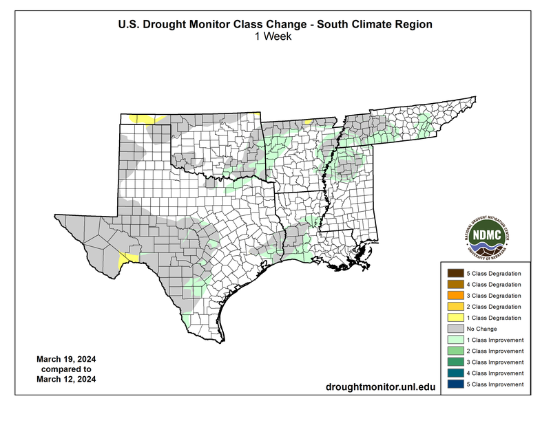
Across the Southern Region, overall coverage of Abnormal Dryness (D0) to Exceptional Drought (D4) takes up almost 50% of the land area. Dry conditions for the past two months in the Southern Region contributed to widespread expansion of (D0) conditions in every state. Fortunately, heavy rainfall from the previous week, observed along Texas’ southern border and eastern and central Tennessee, led to improved drought conditions. Dry conditions and soil moisture deficits in western Tennessee prompted an expansion of (D2) severe drought to 14% of the state. Last week’s precipitation, discussed above, will be considered in the next assessment of the drought monitor.