08/03/2025 - 08/09/2025
Climate in the News:
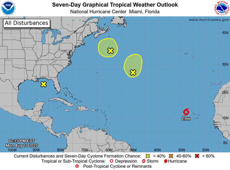
The National Hurricane Center is tracking Tropical Storm Erin, which formed west of the Cabo Verde Islands near the African Continent. Erin is forecasted to move west for the next several days. In the eastern and central Gulf (marked with the yellow ‘x’), atmospheric conditions have favored numerous moderate to strong convection today (August 11).
Weather Synopsis:
The beginning of last week was rainy and cool for most of the Southern Region. A family of low-pressure systems (pictured below) brought a stationary front that draped across the Panhandle to the northeastern portions of Texas, coastal Louisiana, and coastal Mississippi. In Texas and Oklahoma, cooler air dominated the stationary front and brought it southward. By Wednesday night, the stationary front moved away from the Southern Region, leaving behind an area of high pressure. Rainfall produced by the front moved northward to train over the eastern halves of Mississippi and Tennessee. In the middle atmosphere, a high-pressure center stayed over West Texas throughout the week. Its influence expanded eastward, bringing warmer temperatures back to Texas, Oklahoma, Arkansas, Louisiana, and western Tennessee in the latter half of the week. West Texas and Oklahoma had especially favorable conditions for high heat last week.
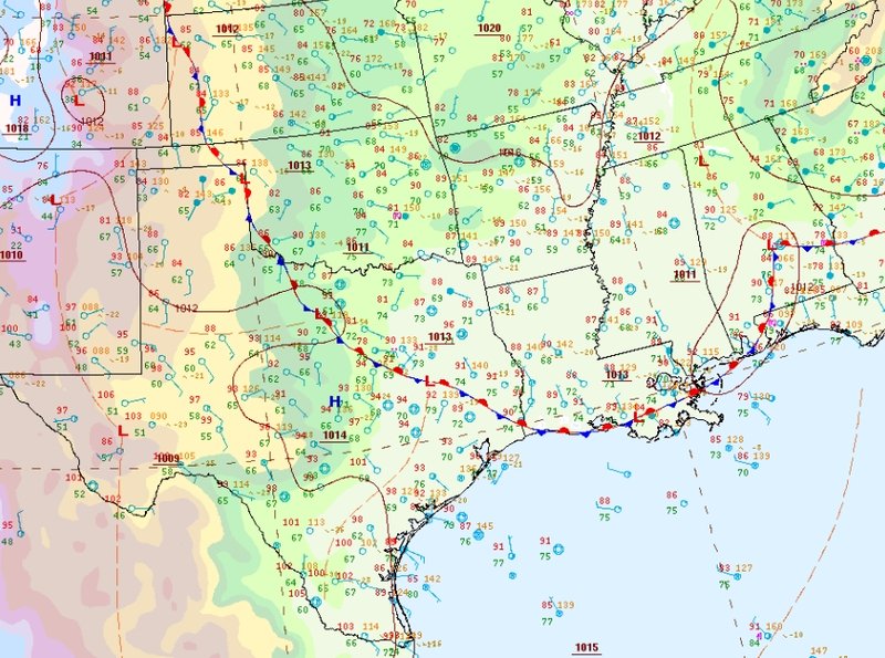
Weather Prediction Center’s Surface Analysis valid 4pm CDT on August 3rd, 2025.
Temperature:
Climatologically, August is the hottest month of the year for the Southern Region, with an exception for Tennessee. The Region often sees daily average temperatures in the mid 80s.
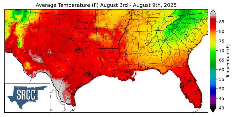
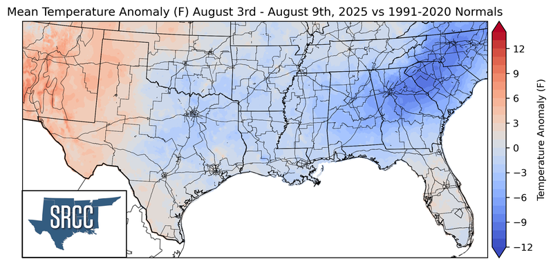
Most of the Southern Region felt cooler than normal last week due to consistent northerly winds behind the stationary front. Persistent cloud cover and several days of light rainfall contributed to 5-8 degree anomalies in Texas, Louisiana, and Mississippi. Hot daily average temperatures near 90°F only affected Texas this week, especially in the South and Trans Pecos. Overall, daily average temperatures ranged from the low 70s to the low 90s.
Precipitation:
With most of the Region located in a humid subtropical climate, rainfall occurs at any point of the year. During the summer months, sea breezes initiate thunderstorms and rain showers, which are quite common along the coastal areas. Tropical systems begin to impact the Southern Region’s weather patterns both directly and indirectly.
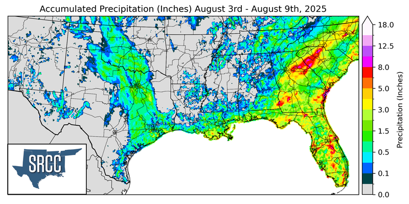
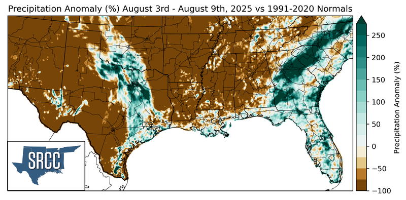
Much of the Southern Region was dry last week. Most of Texas, Arkansas, Oklahoma, and Louisiana were particularly dry for this time of the year. A stationary front produced widespread rainfall on Sunday and Monday in Texas and Oklahoma. Most of the rainfall was light and scattered across Louisiana, Mississippi, Tennessee, and Arkansas. Last week’s highest rainfall accumulation was 4.92 inches in the Texas Upper Coast.
Drought:
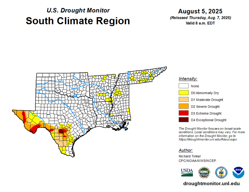
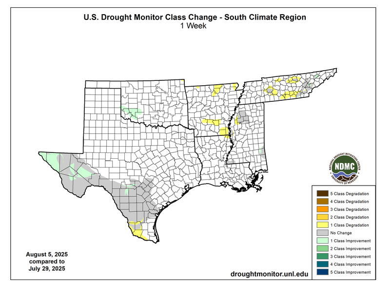
Moderate drought conditions reemerged in Tennessee, for the first time since spring rainfall ameliorated it by mid-May. Abnormally dry conditions developed across Arkansas after a few relatively dry weeks. Previously existing dryness also expanded west in the Mississippi Lower Delta, farther south in Texas, as well as scattering throughout Tennessee. The previous week’s moderate to heavy rainfall brought improvements to drought and abnormally dry regions in Oklahoma and Texas. Oklahoma was drought-free, but the rainfall in Texas was not enough to alleviate years of low groundwater and reservoir levels. Exceptional and extreme drought conditions continue to plague part of the Edwards Plateau and a small portion of the southern Trans Pecos. Fortunately, the state saw widespread improvements in the Trans Pecos and upper South Texas regions. Despite the improvements, almost a quarter of the Texas cotton crop and half of its oat crop were in poor to very poor conditions, according to the USDA. Last week’s precipitation, discussed above, will be considered in the next assessment of the drought monitor.