07/20/2025 - 07/26/2025
Climate in the News:
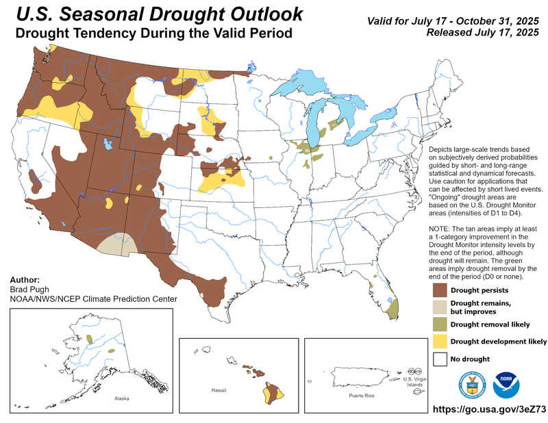
Global climate patterns and the Climate Prediction Center’s seasonal outlooks favor drought persistence in Texas—high summer temperatures may mean recent drought improvements are short-lived. Temperature outlooks indicate a high likelihood of above-normal temperatures for August through October. From July 31 to August 1, NWS predicts a slight risk of extreme heat for most of Texas into southern Oklahoma. Many counties across Oklahoma and northeastern Texas are already under a heat advisory. Extensive rainfall in Texas in early July reduced the chances for excessively high temperatures in areas where the rain fell during the rest of the summer.
Weather Synopsis:
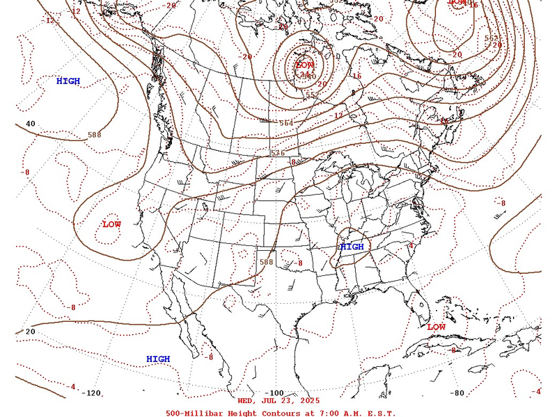
Last week, the Southern Region experienced its characteristic summertime weather pattern affectionately called the “Ring of Fire.” An area of “HIGH” pressure (pictured over Tennessee on Wednesday) brought hot temperatures as it moved northward from the coast and sat there until Friday, when it gradually moved eastward. Moisture flowed inland on the west side of the High pressure. Disturbances tapped into the moisture, leading to a ring of thunderstorms around the area of high pressure. At the end of the week, a low-pressure system draped diagonally across central Oklahoma and the Texas Panhandle brought severe weather and heavy rainfall.
Temperature:
Climatologically, July is the 2nd hottest month of the year for most of the Southern Region. The Region often sees daily average temperatures in the mid 80s.
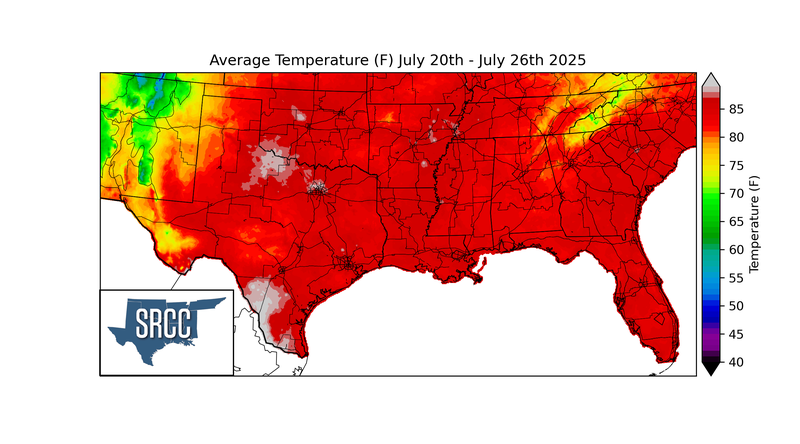
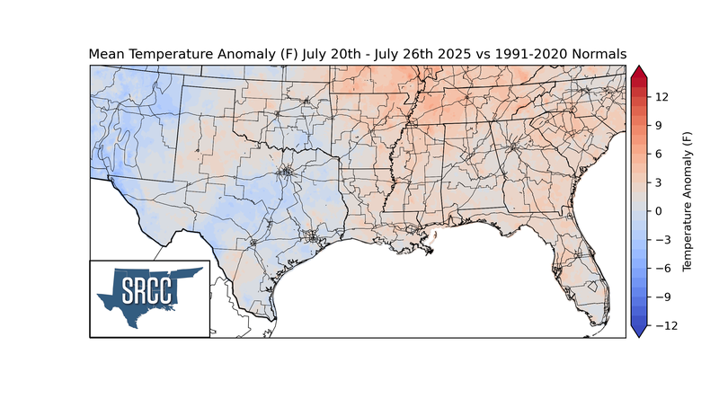
Summer-like temperatures returned across the Southern Region last week. After weeks of cooler-than-normal temperatures, most of Texas and Oklahoma returned to normal and hotter daily average temperatures. On the other hand, northwest Arkansas and Tennessee saw another hot week with 3-6 degrees Fahrenheit above average. Hot daily average temperatures near 90°F affected every state in the Southern Region, even in North Texas and Oklahoma. Such temperatures are 3-6 degrees Fahrenheit warmer than average for this time of year for Arkansas, Louisiana, and Oklahoma. Overall, the average temperatures for the week ranged from the 70s to the low 90s.
Precipitation:
With most of the Region located in a humid subtropical climate, rainfall occurs at any point of the year. During the summer months, sea breezes initiate thunderstorms and rain showers, which are quite common along the coastal areas. Tropical systems begin to impact the Southern Region’s weather patterns both directly and indirectly.
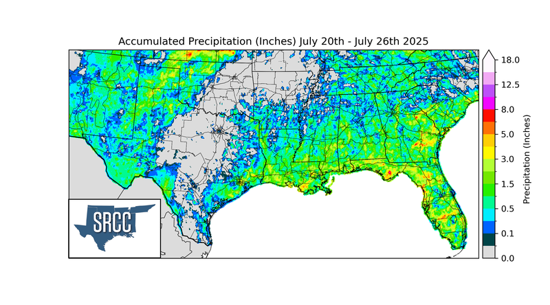
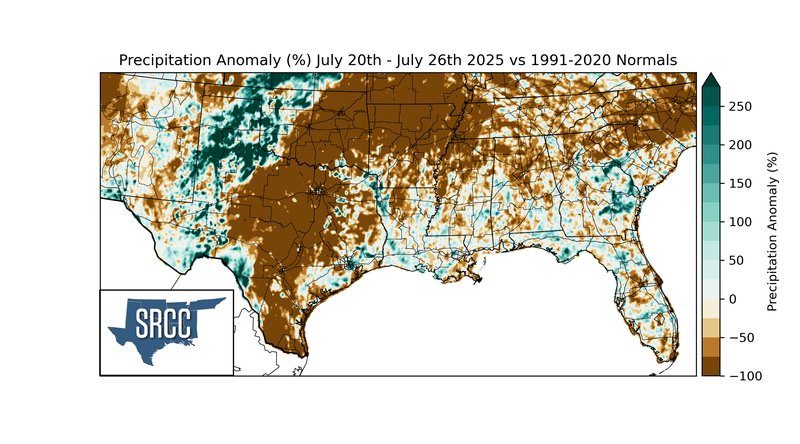
The Southern Region was relatively dry last week. Most of Arkansas, Tennessee, Oklahoma, and Texas were particularly dry for this time of the year. The week’s highest rainfall accumulation was in Slidell, Louisiana, with 5.85 inches. Otherwise, rainfall was most notable in the western half of Texas and Oklahoma, the ArkLaTex region, and the coastal regions. Over 3” fell in parts of every state except for Arkansas.
Drought:
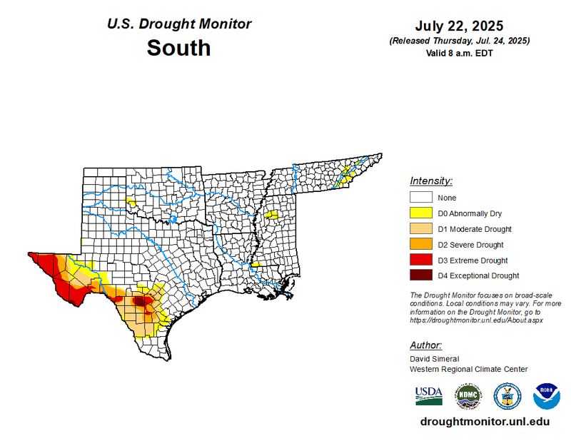
Abnormally dry conditions developed in Mississippi and expanded in Eastern Tennessee, while Louisiana no longer experienced dry conditions due to adequate rainfall. In Texas, (D4) Exceptional Drought continues to plague the Edwards Plateau and Trans Pecos regions. Fortunately, the state saw widespread improvements in the Trans Pecos, southern Texas Edwards Plateau, and northern South Texas regions. Abundant rainfall from the first three weeks of July contributed to drought amelioration for a few counties in the southern Edwards Plateau region. Unfortunately, the rainfall was not enough to ameliorate years of low groundwater and reservoir levels in the South and Trans Pecos. Last week’s precipitation, discussed above, will be considered in the next assessment of the drought monitor.