07/13/2025 - 07/19/2025
Climate in the News:
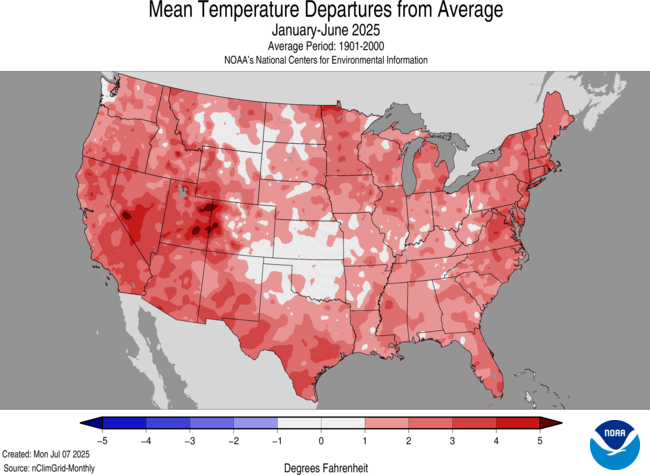
NOAA’s analysis on temperatures and precipitation for June 2025 in the Contiguous U.S. found that it was one of the warmer and wetter Junes on record. The average temperature from March through June this year is 58.38°F, ranking it the second-warmest spring-to-early summer period on record. The warmest was recorded in 2012, which was also the warmest year on record for the CONUS. Temperatures over the past six years have been some of the highest the country has experienced. The past 2 years (July 2023-June 2025), the past 4 years (July 2021 – June 2025), and the past 6 years (July 2020-June 2025) all saw the highest average temperatures on record.
Weather Synopsis:
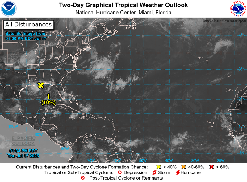
A tropical disturbance (marked by the yellow X) moved west from the Atlantic coast of Florida to the northern Gulf. The disturbance did not develop into a Tropical Storm or stronger while in the Gulf. Instead, it brought abundant moisture to coastal Mississippi and Louisiana. The disturbance brought showers to the Louisiana coast on Wednesday night, and the state received its heaviest round of rain on Friday. By Thursday night, the disturbance weakened to a broad area of low pressure, impacting central Texas in the form of scattered showers. A separate low-pressure system flooded central Texas from the beginning of the week through Tuesday. Southern portions of the state experienced a flash flood emergency on Sunday due to excessive rainfall.
Temperature:
Climatologically, July is the 2nd hottest month of the year for most of the Southern Region. The Region often sees daily average temperatures in the mid 80s.
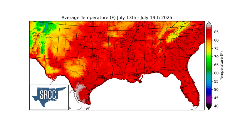
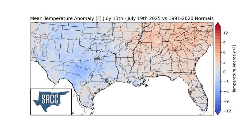
Similar to the week prior, temperatures last week were below normal in Texas and Oklahoma, seasonable in Arkansas and Louisiana, and above normal in Tennessee and Mississippi. Hot daily average temperatures near 85°F affected every state in the Southern Region, and parts of South and East Texas soared to low 90 averages. Such temperatures are 3-6 degrees Fahrenheit warmer than average for this time of year for those locations. Texas and Oklahoma experienced their third week of cooler-than-normal temperatures, due to persistent cloud cover and several days of rainfall. Daily average temperatures in central Texas were 3-6 degrees Fahrenheit below normal. Overall, the average temperatures for the week ranged from the 70s to the low 90s.
Precipitation:
With most of the Region located in a humid subtropical climate, rainfall occurs at any point of the year. During the summer months, sea breezes initiate thunderstorms and rain showers, which are quite common along the coastal areas. Tropical systems begin to impact the Southern Region’s weather patterns both directly and indirectly.
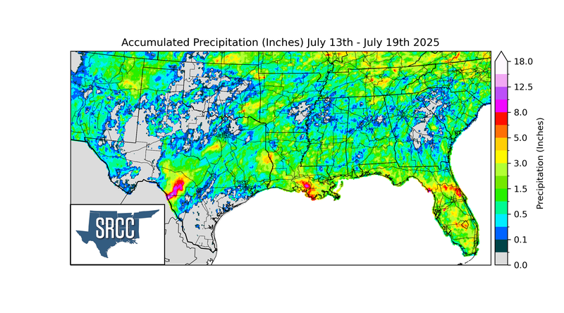
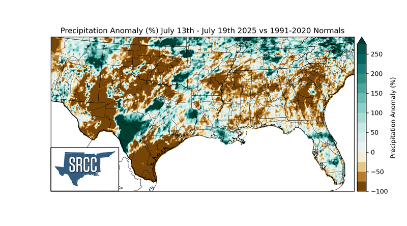
The Southern Region had the largest rainfall totals in the contiguous U.S. last week. The Texas Edwards Plateau and Southeast Louisiana both recorded over 11” of rainfall. On Sunday alone, 4-10 inches fell in the Edwards Plateau and South Texas regions, Southeast Louisiana, and Coastal Mississippi. Some other areas in the Southern Region, such as Northwest Arkansas, Northeast and Southeast Oklahoma, and North Central Texas, also received more than 6 inches of rain during the week.
Drought:
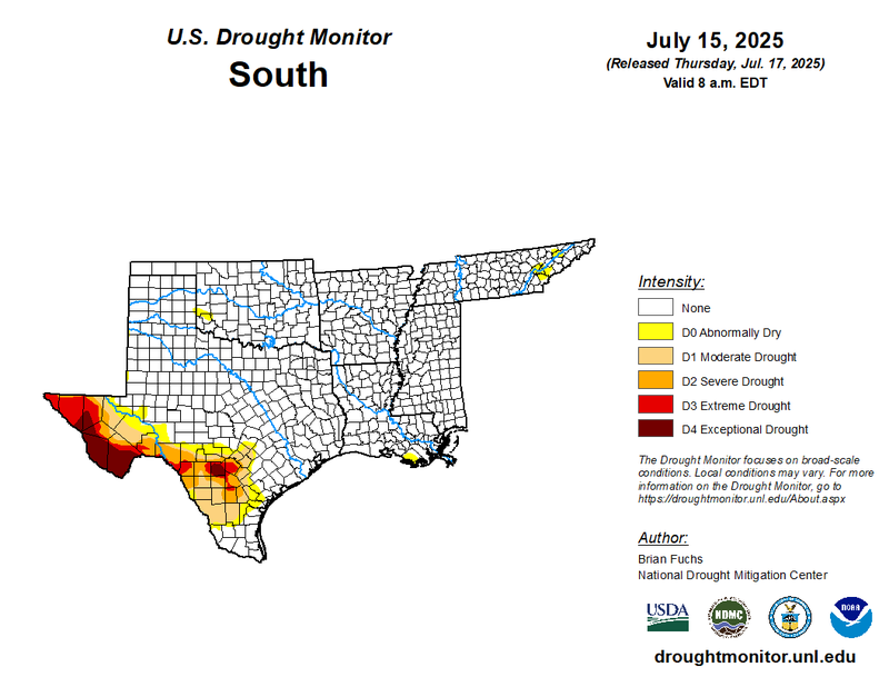
Abnormally dry conditions expanded in Eastern Tennessee. In Texas, (D4) Exceptional Drought continues to plague the Edwards Plateau and Trans Pecos regions. Fortunately, the state saw drought improvements, most significantly in the southern Texas Edwards Plateau region, due to heavy rainfall from the first two weeks of July. Unfortunately, this was not enough to ameliorate years of low groundwater and reservoir levels in the southern portions of the region. Southwestern Arkansas no longer experienced abnormally dry conditions due to consistently cooler temperatures and adequate rainfall. Last week’s precipitation discussed above will be considered in the next assessment of the drought monitor.