06/29/2025 - 07/05/2025
Climate in the News:
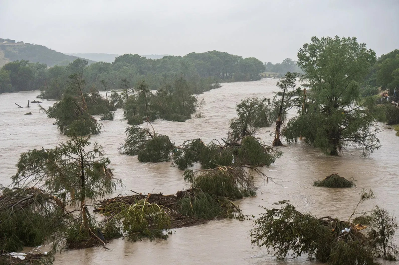
Flash flooding in central Texas was produced by a 1-in-a-1,000-year rainfall event, which is an intense deluge thought to have roughly a 0.1% chance of happening in any given year. Moist air left over from Tropical Storm Barry and Hurricane Flossie created conditions for repeated thunderstorms in one location, according to Texas Climatologist John Nielsen-Gammon. These thunderstorms expelled excessive rainfall within 48 hours by midnight on July 4th, leading to a rapid rise in water levels in the Guadalupe River. The river rose to its highest level in at least 93 years, peaking at almost 50 ft near Bergheim, Tx! Over inches of rain fell in just 3 hours in the early morning of July 5th, creating flash flooding emergency conditions in low-lying areas and worsening water levels. Many search-and-rescue efforts are ongoing to recover missing people caught by the destructive and deadly floodwaters.
Weather Synopsis:
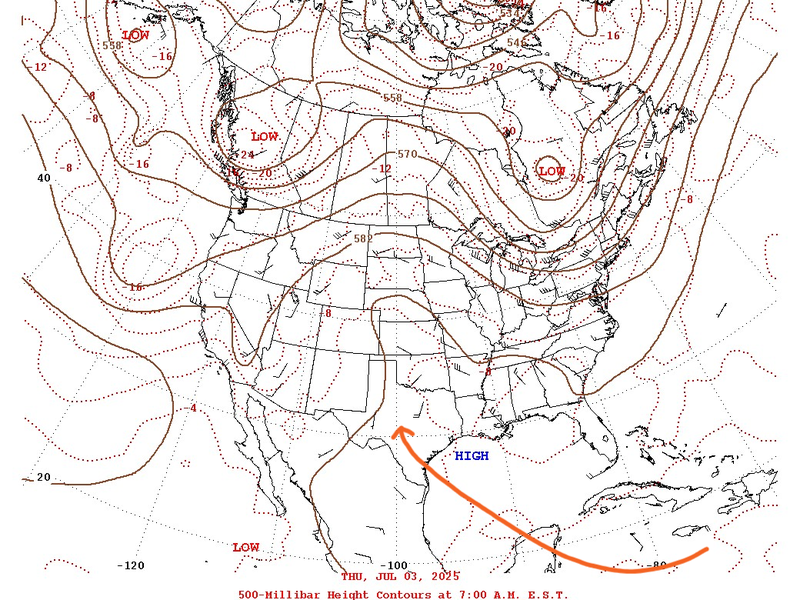
Last week, the Southern Region saw a surge of moisture. Early in the week, cold fronts brought severe weather and heavy rainfall to Mississippi, Oklahoma, Arkansas, Louisiana, Eastern Tennessee, and the Texas High Plains. At the same time, moisture was streaming into Texas, especially in the western part of the state. Water vapor from the Gulf pumped inland (its path shown by the orange arrow) for several days, allowing central Texas to receive tons of atmospheric water vapor that could turn into rain. Additional conditions created by Tropical Storm Barry and Hurricane Flossie contributed to stagnant, rain-heavy storms.
Temperature:
Climatologically, July is the second-hottest month of the year for the Southern Region. Most of the Region often sees daily average temperatures in the mid 80s.
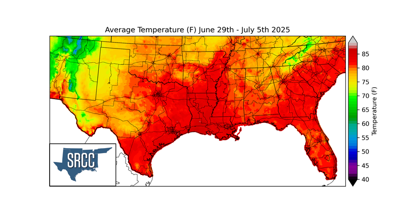
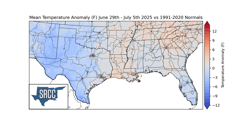
Last week, temperatures were seasonable for most of the Southern Region. Hot daily average temperatures near 85°F affected Louisiana, East Texas, East Arkansas, and West Mississippi. However, the western halves of Texas and Oklahoma were cooler than usual due to the influx of moisture and daily rainfall. The southern border of Texas is usually the hottest part of the Region and sees the warmest temperature anomaly every week. However, South Texas dipped to 6°F below average temperatures, marking it the lowest temperature anomaly in the Region. Overall, the average temperatures for the week ranged from the mid-70s to the high 80s.
Precipitation:
With most of the Region located in a humid subtropical climate, rainfall occurs at any point of the year. During the summer months, sea breezes initiate thunderstorms and rain showers, which are quite common along the coastal areas. Tropical systems begin to impact the Southern Region’s weather patterns both directly and indirectly.
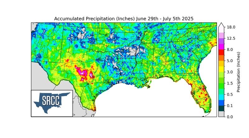
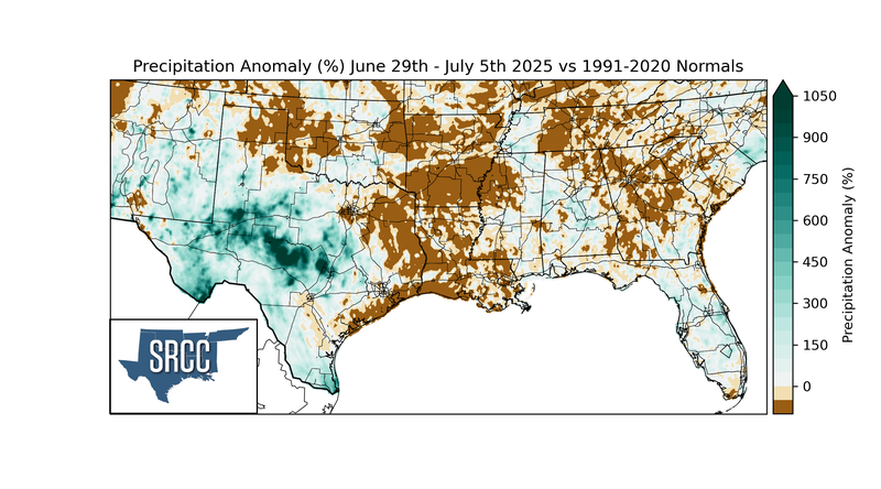
Last week, moist air left over from Tropical Storm Barry in the Atlantic and Hurricane Flossie in the Pacific created conditions for repeated thunderstorms in the Southern Region. The highest accumulations, the most intense, and the most widespread rainfall occurred in the Texas Edwards Plateau region. Up to 21.46 inches of rainfall accumulated in flash flood-prone river basins between July 1st and July 5th. Few other areas in the Southern Region, such as West Texas, East Oklahoma, and Coastal Mississippi, accumulated 6 inches of rainfall for the week. Last week’s rain event in Texas produced 10 times their normal rainfall this time of the year for the areas shaded in dark green.
Drought:
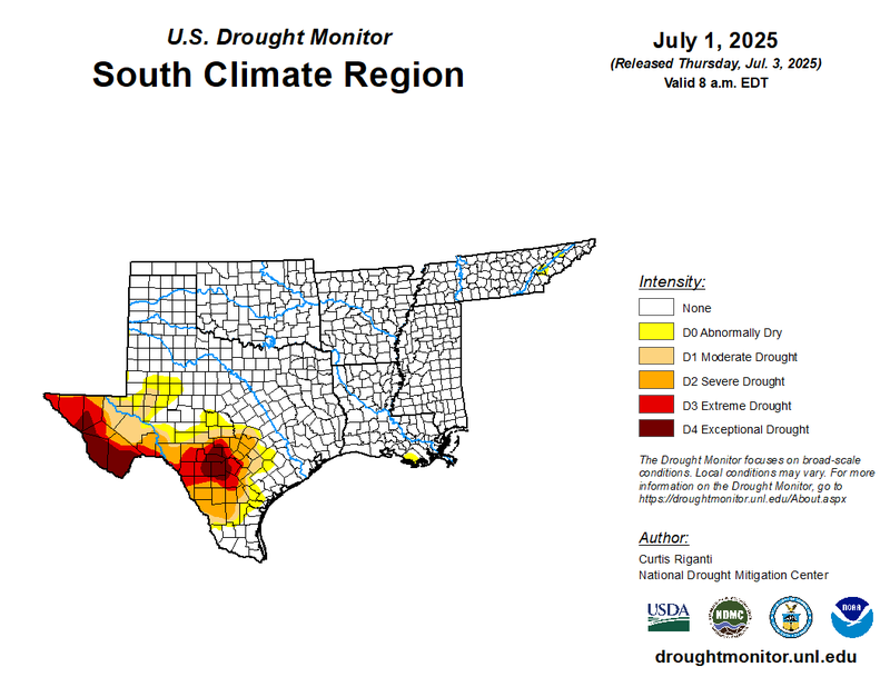
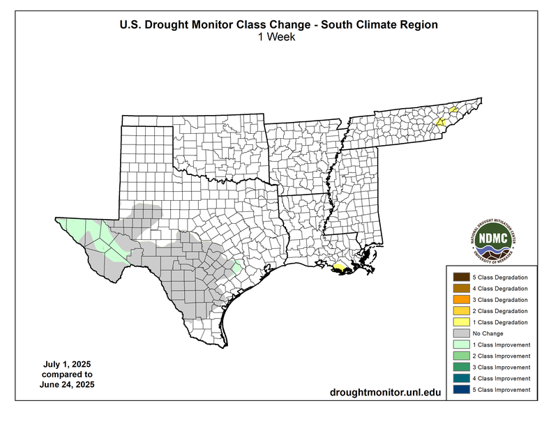
Texas is no longer the only Southern Region state affected by dryness for the first time since early June. Eastern Tennessee and Southeast Louisiana experienced (D0) Abnormally Dry conditions due to little rainfall in June. Exceptional Drought (D4) continues to plague the southern Edwards Plateau and Trans Pecos regions. The North American Monsoon brought abundant rain and cooler temperatures to West Texas’s relief, alleviating effects from long-term (D3) Extreme Drought and (D4) Exceptional Drought. Last week’s precipitation, discussed above, will be considered in the next assessment of the drought monitor.